Wednesday, May 18, 2016

Adventures With Steve And Marsha: The C&O and Great Allegheny Passage (GAP) Trails


IMG_2662.JPG
Marsha and I had reason travel from Connecticut to Kentucky for a family wedding. Along the way we decided to check out two rail trails we had heard a lot about, The Great Allegheny Passage and the C&O Trail.  Together, they provide a bike path between Pittsburgh and Washington DC. Here is a recap of our adventure.

The Great Allegheny Passage Trail or GAP as it is known, is a rail trail that runs 149 miles from Pittsburgh to Cumberland, Maryland. In downtown Cumberland it connects to the C&O Canal Trail and continues on 185 miles to Washington DC, to form a stretch of  334 miles of rail trail riding. The GAP trail is the younger of the two sections and has a better surface. The average grade is 1-2% and overall follows the valley of the Youghiogheny River upstream from Pittsburgh, rising slowly to the Eastern Continental Divide at mile 125 and drops into Cumberland losing about 600 feet. The C&O follows the Potomac into Washington so it is downstream from Cumberland but mostly follows the old canal towpath losing only 600 feet over the 185 miles. Because the C&O is “flatter” it tends to be more muddy and as it is the older of the two sections, it is probably overdue for resurfacing and drainage corrections.

The GAP trail coming onboard second, benefitted from the lessons of eco-tourism and features more options for off trail lodging in B&B’s and Inns. It also built upon a tourism structure in place from the whitewater kayaking and rafting in place around the Youghiogheny River in Ohiopyle, PA. Besides whitewater Ohiopyle is home to the large Ohiopyle State Park and has attractions such as the Falling Waters House and Kentuck Knob House designed and built by noted architect Frank Lloyd Wright. The C&O features primitive campsites along the path. However, it is possible to easily find indoor accommodations along the C&O and conversely camping along the GAP trail. Both trails have benefitted from the recent changes in Amtrak’s bikes on board policies. You can roll on a bike with a reservation on trains that run between Washington and Pittsburgh and get off/on at several stops along the way.

Our adventures happened as a scouting trip for future riding. We attended a family wedding in Kentucky and took some time outbound to stop in Cumberland to check out the C&O. On the return trip stopped in Ohiopyle to explore the GAP trail. We were inspired by veteran TCC rider Dave Waldburger who said he had ridden it (what has he NOT ridden!) and my memories of paddling the “Yock” in those halcyon days of whitewater glory when my back was younger and allowed my roll to be bombproof (mostly).

Our stop in Cumberland was short, wet and muddy. Just outside the C&O visitor’s center in downtown Cumberland was a Fairfield Inn, so we booked a night as a stop on our way. Very nice but downtown prices. We set off in cloudy but mild conditions and soon encountered rain. It had been rainy in MD for about a week and a half and the trail was puddle filled for longer stretches and gouged with mud tracks.


We went out only about 7 miles and between the intermittent rain and mud decided that a meal of seafood at Crabby Pig near the hotel was a better choice. I remember looking down at my front chainring and seeing about 2 inches of mud covering the derailleur and about the same on my shoes and legs. We stopped at a primitive campsite and used the pump to wash the mud off the critical bike parts and continued on only to find that the mud was back in force within 10 minutes of riding.  It was good that we flipped back early as Marsha picked up a slow leak flat about a mile from the end and in our exuberance to get our legs moving after 6 hours of driving and to beat the rain neither of us had slapped on our tool kits and pumps. It was just a quick out and back afternoon ride for goodness sake.

Careful riding got us back to the hotel and here took place some post facto learning. At the side of the hotel was a bike was wash down station sponsored by the bike shop just down the street. It had space for six bikes to be parked, a hose and a wipe down rag. Looks like this “muddy trail” thing is a permanent feature of the C&O near Cumberland and the hotel which allows bikes to be brought to the rooms found it prudent to partner with the bike shop to leave the mud outside. A quick wash of bikes and lower persons got the mud away. The hotel was a good host and besides bikes in the room, and breakfast included, had  coin laundry services so we got to wash out the remaining mud from our clothes and get things dry. Oysters on the half shell and softshell crab sandwiches at the Crabby Pig for dinner eased any remaining disappointment in shortness of the ride, the rain, the flat tire, and the mud.


On the return from Kentucky, we stopped in Ohiopyle, PA to explore the GAP Trail. We stayed in Ohiopyle State Park and booked a “yurt” for a few days. It was our first stay in a yurt and quite pleasant. The yurt had a refrigerator, electric stove, tables chairs, a microwave and bunks for 5. You had to fetch water from a pump and wash dishes in the designated sink area of the bathroom. Bathrooms had showers, and outside the yurt was a small deck and a grill for cooking and a fire ring for campfires. Best of all for us was that it had electric outlets to charge up our electronic devices, and by making a phone a wifi  hotspot I could deliver my daily dose of sarcasm to Mike Babinski on Facebook. Except for a few too many ants and some rustling and nibbling sounds in the night (keep your food in the fridge or car) life is good in the yurt.

Ohiopyle has long been a whitewater center. In talking to a local shopkeeper she related that in recent years the whitewater rafting business has tailed off (as it has across the country) and the completing of the GAP trail in 2013 has brought a new surge of tourism. The new bike tourism activity spans more age groups and spreads the “wealth” up and down the valley. It can be done in a longer season from early spring to late fall. Retirees, families and groups have fueled the need for more places to stay, more places to eat and more services like shuttles and bike shops. Biking now is the number one attraction over whitewater. Are we paying attention, Airline Trail?

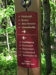
We did a 35 mile round trip on Day 1 from Ohiopyle to Connellsville and back. Wonderful day, wonderful weather and great surface all the way. It is a wide track through the verdant hillsides of PA with the Yock rapids running down below.
 

Outbound we came up behind a group of gray haired folks like us riding two abreast in a 4 pack so we pulled in behind to chat for a bit and find a spot to go by politely. As we rode along, I was on right and an inexperienced gal rider in the lead of my column decided to slow down and stop by pulling slightly right. Next gal in line goes into the back half of her bike and down. Sweetness (my Trek 520 touring bike) and I go over the back part of the rear tire of the second bike and I go over the handlebars. Thankfully a very soft landing for me. Clipped out pretty much and avoided most of the mess by swinging hard right. Second rider got a leg wedged into the triangle of the frame, cracked her helmet on something and was showing some signs of confusion and perhaps concussion. Sweetness took it all in stride. Luckily we were about 2 miles outside of Connellsville.  Her group was able to have her stop at at a park on the edge of town and coordinate a car  to come back and get a her to a medical facility to double check the concussive signs. The first rider rider (sans helmet) did not do a good job of communicating her intentions and bears a lot of the fault, but overall it was a group of inexperienced folks, several without helmets, not familiar with how a pleasent day biking in a group going down a wide open trail can turn into a pile up. TCC lessons: accidents happen more frequently in the latter parts of rides, in larger groups, and when we have a lapses in frequent, clear, communication of intent, especially slowing and stopping. Sing it out clear and loud, use your hand signals and for heaven’s sake even on a flat easy non-vehicle traffic trail ride, wear a helmet. The injured rider cracked her helmet  going down on something. The first rider could have done the same but it would have been her head.


Pizza slices in Connellsville for lunch and a stop at the Froyo shop for a treat before heading back. On the way inbound we stopped to help a retired couple who had a major mechanical. They were from Bend OR and doing the bikes on/off  Amtrak thing for the GAP from Cumberland to Pittsburgh and staying at B&B’s.  They had flown out and had rented bikes. The previous year they had done the same on the C&O. On the gal's bike the entire bottom bracket had come loose. I mean the entire bottom bracket. I have never seen as much of the guts of a bottom bracket since I tried my hand at bike wrenching and took apart an old bike for practice (and have since paid good money to the folks at Scott’s and Sunshine to take care of that stuff for me). It was like the entire bracket had come unscrewed as she had pedaled.  She could pedal in one gear but the crank arms were wobbling and floppy. She had 10 miles (at about a 2% downhill grade) to the next town with a bike shop. There are couple of places on the trail equipped with a repair stand. Several different bike tools on lengths of metal wire and a way to hang your bike for repair work. Even has a air pump. And there is a QR code you can scan that takes you to a bike repair website. None this was going to help this major breakdown. Note to TCC: Let’s make these repair stations happen on the Airline and Hop River trails!

Day 2 ride was much less eventful. After a leisurely morning (yurt camping will encourage that) we went upstream to just past Confluence for about a 30 mile day. Confluence was one of the places the young Colonel George Washington camped his British and Virginia militia troops in his efforts to secure an overland water route to what is now Pittsburgh during the French and Indian War.  Today Confluence is a small river town that lives off river and trail tourism. Lots of places to spend the night, or to grab a bite to eat, and a nice bike shop whose owner is from Portland, CT. We looped back into Ohiopyle going downstream (which is slightly downhill) stopping to admire several Class 4 rapids.

And on Day 3 it rained.  As I write this I am sitting here in the yurt, all warm and cozy, electric heater blazing in the sleeping area, watching the rain pelt against the clear vinyl window covering. The contemplated 45 mile trip for today, is slowly dissolving into the smells of hot coffee, French toast with maple syrup and bacon. Weather radar has another two hours of hard rain. The tours of Falling Waters don’t start until noon. The Kentuck Knob house is closed today. The chef is dishing up her portion of breakfast mumbling something about “not seeing any problem with riding in the rain”. Negotiations resume in earnest when she sits down at the table. Thankfully, we only brought the plastic knives and forks.

Steve Sokoloski


Sunday, May 15, 2016

The Natchez Trace Parkway - Cycling Nirvana in the Deep South

The Riders: John Hankins, Beth Hudson-Hankins, Phil Forzley, Bill Penn When: April 23-26, 2016
Imagine you could design the perfect road for bicycling. You’d make it hundreds of miles long, so cyclists could go on rides of any length. You’d be sure that the pavement was silky smooth and you’d locate the road in a region where frost and the damaging freeze-thaw cycle were unknown. Since this would be a warm climate, you’d be sure that trees near the side of the road were large enough to provide a shade-producing canopy for the riders. To keep the setting natural and scenic you’d ban any kind of development along the road – no commercial strip malls, no houses, no mailboxes, not even any powerlines. The pavement would be pitched to drain to grass strips on both sides so that you could avoid curbing and catch basins. Where another road intersected, you’d design a bridge or an underpass, so that for hundreds of miles there would be no stop signs or stoplights to interrupt the journey. This strategy would largely prevent local vehicle traffic from entering the road, to the point where only about one car would pass every five to ten minutes. Trucks and other commercial traffic would be banned. Finally, you’d make sure that the road was in a region where people were so darned courteous that drivers would give bikes a minimum of 12 feet of room when they passed, often greeting the cyclists with waves and thumbs up of support.
Amazingly, such a place exists. It’s called the Natchez Trace Parkway and it runs for 444 continuous miles from Nashville, Tennessee to Vicksburg, Mississippi, crossing the northwest corner of Alabama along the way. I had heard vaguely of the Natchez Trace previously, but because it was located in a part of the world where most northerners dare not tread, I had not researched it further. That changed during the winter of 2016 when my wife Beth and I started looking for a Spring cycling junket that would move us forward on our quest do a 100-mile century ride each of the 50 states. As I scanned the Rand-McNally Road Atlas on a cold January night, I became intrigued about the idea of a ride in Alabama and Mississippi. We had our century ride in virtually all the states along the eastern seaboard and were looking for the next frontier. I started googling around for bike routes in the deep south and the Natchez Trace was a recurring theme on many of the websites.
I learned that the Natchez Trace was originally a series of Indian trails that slowly coalesced to form a continuous path from the Mississippi River over low hills to the valley of the Tennessee River. By the 1700s, the French were showing the trail on maps of the area. Later in the 1700s, farmers in the Ohio River Valley seeking markets for their crops were floating flatboats down the Ohio and Mississippi Rivers to ports in Natchez and New Orleans. Their flatboats had the unfortunate characteristic that they could only go downstream, so they’d sell their boats for lumber at their final destination and walk home or hitch a ride in a wagon. By going overland on the Natchez Trace they could take days or weeks off the less direct route along the river valleys. There was enough traffic on the early Natchez Trace to support at least 20 inns along the route. Use of the Natchez Trace dwindled after steamboat service was established on the Mississippi starting in 1812 and people no longer needed to walk home. The inns closed down, and the once bustling route returned to its former condition as a peaceful forest lane for the next 120 years or so.
The Depression of the 1930s brought Franklin D. Roosevelt’s New Deal and the Civilian Conservation Corps, a program that put thousands of people back to work. Construction of a scenic national parkway along the original route of the Natchez Trace was one of the hundreds of make-work projects around the country that was dreamed up, a project similar to the Blue Ridge Parkway in Virginia and North Carolina. The idea was to give the motoring public the experience of driving through a long stretch of unbroken countryside that looked largely like it might have before the area was settled. A linear National Park was established that was over 400 miles long and as little as a few hundred yards wide. Construction of the Parkway began in the 1930s and was largely completed by the end of that decade, with embellishments continuing for another 70 years. Once Beth and I determined that the Natchez Trace would be part of our upcoming adventure, we spent a little more time with our friends Rand and McNally, and determined that if we played our cards correctly, we could do century rides on the Natchez Trace in Alabama and Mississippi, and then drive across the Mississippi River to hit the States of Louisiana and Arkansas with two additional century rides as we started to wind our way home. We somehow convinced our friends Phil Forzley and Bill Penn to join us on this odyssey, and they agreed to come along despite the fact that we’d be driving 3500 miles for the pleasure of riding just 400.
Once we had our route and our team established, we were left with the fact that we did not have anyone to advance our vehicle as we rode each day. I mentioned this conundrum to my 80-year old mother Jean and she surprised me by saying “Oh, I’d be happy to do that. Yes, I think I’ll come”. As our sag wagon driver she would have certain responsibilities, I explained. She’d need to be able to stay on the route and talk to us on a cell phone to make sure we were OK. Most importantly, she’d need to navigate the van to an agreed upon meeting spot each day that none of us had ever been to. My mom’s always been an adventurer, so I wasn’t terribly worried about the navigation part of the equation; however, communication was another thing – she owns a cell phone that she purchased about 10 years ago, but I’m pretty sure she had never used it before the trip. In addition, her hearing isn’t so good, so talking on a cell phone, especially with the bad service in the rural areas we’d be traversing, would be a major challenge. In the words of a friend – “You’ve got an 80-year old woman driving a large unfamiliar vehicle across a region she’s never been to, relying on her limited hearing to use a cell phone that she’s never used as her sole means of communication with you. What could possibly go wrong?” The possibilities were endless.
We skipped the northern-most 100 miles of the Natchez Trace as it traverses Tennessee, a State we’d already done our 100 miles in during a previous trip. Instead, we began Day One in Alabama. The road lived up to its billing, with smooth pavement, gently undulating hills, no traffic and absolutely no development of any kind. There are mile markers along the entire road to gage progress and a myriad of labeled historic sites along the way for those willing to take a quick break in their forward progress. You’d think that on a long-distance ride there would be no possible reason that you’d leave such a road to ride on rougher local highways with more traffic, more development, more hills, and stray dogs, but you’d be wrong. Beth’s unwritten rules of State-based century riding dictate that you can’t “claim” a State in the 50-state quest unless you’ve ridden at least half of your 100 daily miles within the boundaries of said State, and Alabama’s share of the Natchez Trace is just 30 miles. Mr. Forzley had been given the task of designing a route that would meet Beth’s exacting parameters, and he wound us for the last 70 miles of Day One through a surprisingly hilly area of northwest Alabama on a route that terminated in a Pizza Hut parking lot selected by my mother in the Town of Hamilton.
Our ride through Mississippi on Day Two was perhaps the highlight of the trip – an uninterrupted 100 miles of flawless asphalt along a shady highway with almost no traffic. Our normal riding etiquette is for the lead rider to point out road hazards such as potholes, sand and random detritus as they are encountered, which normally happens several times a mile. On this day, however, the road was so perfect that we rode an 40 miles before the first hazard needed to be pointed out, which came in the form of a three-foot long black snake winding his way across the road. These were easy miles - the vertical climb recorded by our Garmin bike computers was less than four feet per mile, as it would be for the balance of the trip. We got our first dose of southern hospitality when we stopped at a little rest area with a snack bar in the town of French Lick. To our chagrin, the snack bar would not be open for another hour and we didn’t have time to wait. As we discussed our misfortunate timing, an older couple appeared out of thin air with half a watermelon to donate to our cause and we consumed the fruit on the spot. Best watermelon ever.
Two great rides in two days with no incidents. This was almost too easy, we thought. Where’s the adventure? When we awoke on Day Three we took a look at the radar and saw an angry red blob heading directly for us from the west. The weather forecasters were predicting heavy rain, wind, hail, and general damnation beginning mid-morning. Undaunted, we had my mother drive us over the Mississippi River at Vicksburg and drop us off in the bustling metropolis of Tallulah, Louisiana.
We headed west from Tallulah into the darkening skies, assuming that the Lord would provide shelter from the impending storm. The forecasted damnation took a form we were not expecting when at the 15 mile mark we took a right turn in Waverly, LA onto the roughest pavement we’d seen so far. Within about 100 yards of this I dropped into a pothole whose geometry was such that it grabbed my front tire and yanked it hard to the left. With my front wheel now pointing 45 degrees to the left and my body continuing to move forward at 20 mph, I was pretty sure nothing good was going to happen. I was correct in that assessment - my body went into the pavement to the right, and my bike went to the left, giving Mr. Forzley a chance to practice his BMX skills by riding directly over my really expensive carbon wheels without crashing himself (pretty sure he had been waiting to do this for years). After moaning about the injustice that I had just experienced, I rose from the pavement to assess the damage. Road rash, a chunk of flesh missing from the elbow, and a sore hip and shoulder. Remarkably, after riding through hundreds of miles of nothingness, the crash happened directly in front of the main office for a grain distributor. They had a friendly staff and a well-stocked first aid kit that Phil used to wrap up my elbow well enough so that I would not leave my DNA on the van seats on the way to the emergency room. It turned out there was a hospital only a few miles away and my mother had fortuitously pulled up behind us only a few minutes after our untimely stoppage. As we arrived at the emergency room, the first raindrops started. My compatriots thanked me for my good judgment in timing my crash just before the thunderstorm arrived so that they could enjoy a few dry hours in the Delhi, LA hospital waiting room reading back issues of People magazine.
After x-raying my elbow to establish there were no embedded rocks, the nice staff stitched me back up and declared me fit enough to ride on. We had a leisurely lunch at the local greasy spoon to let the roads dry, and then returned to the scene of the mishap to pick up where we left off, with 85 miles still to go. A quick scan of my bike determined it was no longer ready for prime time; however, in a stroke of genius, we had brought an extra bike for just this eventuality. The backup bike was the Trek 5900 that had been ridden by the late great John Jackman and I’d brought it along partly because of John’s participation in the 50-state challenge for several years with us. In John’s honor, his bike continues the quest. One does not usually embark on an 85 mile ride at 1:00 in the afternoon, and we were not at all sure that we’d be able to get it done. But get it done we did, picking up a strong Louisiana tailwind for most of the balance of the day as we headed north toward Arkansas. The roads continued dead flat, and with the wind behind us life was good – at one point with Beth in the lead I looked down and we were clicking along at 24.5 mph. Our average for the day, even with all the pace-killing excitement, pushed 19 mph.
We had hoped for an uneventful final day in Arkansas, but it was not to be. Before I even got on the bike in the morning I realized it had a flat, and it took another two tubes over the first 20 miles to realize that all three flats were courtesy of a microscopic wire poking through the tire. With that remedied, it was Bill’s turn to ride the flat tire merry-go-round. Bill later admitted that attempting four 100-mile rides on ancient tires with tread the thickness of wax paper may not have been such a good idea. Between Bill and John they flatted six times, which put us in a bit of a deficit since we only had four replacement tubes between us. A quick call to the sag wagon for replacements proved fruitless as: a) the vehicle was 50 miles ahead of us when we called, and b) my mother could understand virtually nothing we were saying over the scratchy cell phone connection. She adapts well to challenges, however, and realized that because she could hear “yes” and “no” over the phone that she could play 20 questions and get the information she needed. Despite my best efforts, 20 questions was not a suitable media for communicating that we were 4.5 miles south of Podunk, Arkansas under a tree on Route 219 in the driveway of a yellow house. As an alternative solution, we broke out our patch kits and managed to salvage enough of the damaged tubes to finish the ride. Moral of the story: Always bring a patch kit. Second moral of the story: make sure the glue is not dried out as it works better in liquid form.
The last 20 miles or so of our fourth and final day in Arkansas were without incident and we found my mother right where she was supposed to be at the 100-mile mark. High fives were shared, Beth was congratulated on reaching the 25-state mark on her march to 50, and we drove a few miles to the nearest town for a well-deserved dinner. Four consecutive 100-mile rides had taken their toll on us, and we hobbled into a restaurant demonstrating a distinct lack of flexibility. The waitress couldn’t help but notice our strange gait as we walked in, and after taking our drink order she exclaimed what we’d heard at virtually every stop along the way “Y’all ain’t from around here, are you?” We asked “What gave it away?” and she responded “Well, you talk different and you walk funny”. After a few weeks back in Connecticut we’re still talking different, but we’re walking much less funny that we were that night in Arkansas. We’re glad to be back on roads that undulate a little more than 4 vertical feet per mile, but hope to return some day to see the balance of the Natchez Trace, a gem of a cycling road with a truly remarkable story.
- John Hankins