
One hundred miles.
You’ll commonly hear cyclists asking each other whether they’ve ever
ridden “a century”, a lofty goal similar to that of completing a marathon for runners. Yes, some people are
able to ride further, but for most, once they’ve gotten to 100 there’s no need to
prove themselves further, except perhaps to go find another century to do
that’s more epic in one way or another.
Once my wife Beth and I realized in the early 2000s that our
40+ -year old knees, hips, and other moving body parts were not going to
withstand decades of additional long-distance running, we started looking for
another way to punish ourselves. We
discovered cycling, and before long both of us were able to complete a 100-mile
ride. We then started searching for
challenging rides and events to do around the country, frequently involving rides of 100 miles or more, many of which are depicted below:
Bike Tour of Colorado, Vail Pass - 2011

John with Daughter Anna, Whiteface Mountain Summit, New York - 2012

Blue Ridge Parkway, Smoky Mountains, North Carolina - 2014

PAC Tour Alaska, 1200 miles in 10 days, Valdez, AK - 2007
 Thread City Cyclers RAGRBRAI Team - Iowa, 2009


PAC Tour Winter Camp, Bisbee, Arizona - 2016

Natchez Trace Parkway, Alabama, 2016

Boulder City, Nevada - 2017
One of our adventures took us to Virginia in 2012, where
there was a six-day ride with a longest day of 80 miles. Beth pointed out that if we just logged 20 miles
before everyone else woke up that we could end the day with 100. “Furthermore”, she said, “wouldn’t it be neat
if we were able to do a 100-mile ride in every State?”. Although initially skeptical, John
ultimately embraced the idea when he realized that this would give him
something to talk about at dinner parties for many years to come. We rode 100 miles that day, bringing our
total to 10 States, and then over the next seven years added another 23, to
bring the total at the beginning of the 2019 riding season to 33

With Friends Bill and Phil, Tennessee - 2014

With Friends Hart and Liz - Salado, TX - 2017

Beth and Friend Bill, Gaffney, Georgia - 2014

Zion National Park - Utah, 2017

PAC Tour, Wisconsin - 2013

Natchez Trace Sag Wagon Driven by John's 81-year Old Mom Jean - Alabama, 2016

Natchez Trace Parkway, Mississippi - 2016

Beth with Friends Phil and Bill in a Sad Town on a Hot Day in Arkansas - 2016

Beth with Friends Jim and Sylvia - Cycle Oregon, 2018
As we checked off the states within a day’s driving distance
of our home base in Connecticut, the pace of our quest has slowed, and in many
years we’ve only been able to add one or two new states to the tally. We realized that with our 60th
birthdays approaching that we’d best get on our horses and get this thing done
or we’d be doing it in wheelchairs. It
was Beth who first suggested the possibility of a whirlwind road trip to grab
the balance of the states in one fell swoop, minus Hawaii due to certain
logistical challenges. I was freshly
retired from a 35-year career and I was looking
for a project, so I embraced this mission with more than a small amount of
gusto. I pulled out the Rand McNally Road
Atlas and started to develop an itinerary that would take us through the 17 remaining
states in the contiguous U.S. in as efficient a manner as possible. Over the course of several months I
researched potential rides, sought lodging with friends we have scattered
across the country, and acquired the pile of stuff we’d need to support
ourselves along the way. This would not
be a self-supported fully-loaded cross-country bike tour in the classic
sense. Instead, we’d pile our bikes and
our mountain of gear into our Dodge Caravan and use the vehicle to hop-scotch across the country to each successive state where a ride was required.
After plotting a route on the map and thinking about
logistics, we realized it would take about seven weeks to complete our task. Our selection of a departure date in mid-May
would be early enough to beat the worst of the summer heat, late enough to
allow the plowing crews to clear the last of the winter’s snows from the high
passes in the Rockies, and at the right time of year to get maximum daylight
for early starts.
On the morning of May 18th we turned the keys to
the house over to a house-sitter, said good-bye to our dog and two cats, called
our moms to tell them we loved them, and pointed the van toward Ohio for our first
test. We had three bikes stowed
comfortably inside – Beth’s Trek Silque, my Cannondale Synapse, and our brand
spanking new Co-Motion Carrera Tandem, painted in “Lusty Red” for maximum speed.
For extra carrying capacity we purchased the largest Yakima roof-top carrier available,
and our loaded rig bore a distinct resemblance to the space shuttle flying back
to Cape Canaveral on the top of a 747.
Our camping equipment went in the cartop carrier. The rest of the stuff rode inside with us,
stacked nearly to the ceiling.
Along the way I endeavored to write a log of our adventures
to share with friends. I’ve included
that log as originally written and have embellished it with some photos we
snapped along the way.
Getting there can be Half the Battle
Prior to the trip I had brought our 2013 Dodge Caravan to
the dealer to have them do a “free 23-point safety inspection”. “Everything’s running great”, I said, “so you
probably won’t find anything”. They
called me a few hours later to say that I needed to replace my struts, various
components of the braking system, and several mysterious mechanical items that
I suspected they had simply made up.
After paying the $2500 bill I was assured that we’d be good to go on our
8000-mile voyage. On the way back from
the dealer I discovered that the air conditioning was out, so I did a U-turn
and brought the car back. “We’ll look at
it right away”, they said, “probably just needs the refrigeration liquid
refreshed”. Later that day I was told we
needed a new condenser for $1,000. A
little while after that they called again to let me know that the cost would be
twice that quoted because various metal parts had seized onto other various
metal parts and the only way to remedy the situation was to start cutting
things up and throwing them away. I
returned to the dealer the next day and gave them some more of my retirement
funds. With our van now worth $5,000
more than it had been three days earlier, we were confident that nothing else
could go wrong.
Halfway to Stroudsburg, Pennsylvania on our first day of
driving the warning lights for the ABS brake system came on as well as a little
squiggly symbol of unknown importance. A
little while later the little engine warning light came on, and a while after
that the cruise control stopped working, which saddened my right foot. I chose to ignore all of these symptoms since
the vehicle was continuing down the road under its own power and the various
issues were not inconveniencing us.
Unbeknownst to us, the Gods that govern all things mechanical had one
more trick up their sleeves. As we went
to close the rear hatch of the van after our first night of camping, the
automatic door latching mechanism got in its head that it would like to unlatch
the rear door every time it was closed, which meant an unlocked unlatched rear
door that would open randomly going down the road for the rest of the
trip. Not good. After a few dozen attempts we were
able to get the door closed but we were then so afraid to open it that we
stopped using the door and for the rest of the trip and accessed our three bikes
and our gear through the side doors.
Weeks 1 and 2 – Ohio, Indiana, Illinois, Missouri, Kansas,
Nebraska
We had a busy start to our bike adventure and only after two weeks on the road did feel like I had the time, energy, and
backlog of amusing anecdotes to provide the first chapter of our
experience.
I’ll get the statistics out of the way first in order to
satisfy those who would like to skip the stories of mishaps, misery, and malfeasance.
Start Point
|
Date
(2019)
|
Riding
Distance (miles)
|
Elevation
Gain (ft)
|
Average
Speed (mph)
|
Max
Speed (mph)
|
High
Temp
|
State
Century
|
Xenia, Ohio
|
5/20
|
101
|
807
|
15.3
|
24.8
|
70
|
#34
|
Tell City, Indiana
|
5/22
|
103
|
6096
|
14.2
|
46.7
|
75
|
#35
|
Golconda, Illinois
|
5/24
|
102
|
8110
|
12.9
|
46.0
|
91
|
#36
|
Poplar Bluffs, Missouri
|
5/26
|
108
|
4626
|
15.5
|
40.9
|
85
|
#37
|
Beatrice, Nebraska
|
5/28
|
102
|
2614
|
16.5 (tandem)
|
35.6
|
68
|
#38
|
Kansas (starting in Odell, NE)
|
5/29
|
100
|
3566
|
15.0 (tandem)
|
33.7
|
75
|
#39
|
Xenia, Ohio – A Rail
Trail Crossroad
As a preliminary planning tool for our trip I had researched
the Rail-to-Trail Conservancy’s “Hall of Fame” list of 25 great rail trails in
the U.S. One of those trails was paved
and happened to be in Ohio, where we had not yet ridden a century. The Little Miami Trail runs for 90+ miles
north of Cincinnati. It connects to a
myriad of other trails providing one of the best networks of improved rail trails
in the country. Ground zero of that
trail network is Xenia, Ohio, the intersection of rail trails that radiate out
in five different directions. 
Xenia Ohio - A Rail-Trail Crossroad
We stayed in Xenia in an AirBNB that Beth and found for a
remarkable and somewhat frightening $38 per night. We had our choice of rooms and chose the room
in the basement, perhaps with the unconscious recollection of the F5 Tornado
that wiped out much of the town and killed a bunch of people in 1994. The downside to the room, which we thought of
while we were trying to go to sleep, was that the only exit was via a steep set
of wooden stairs. That’s not really a
down side unless the house is on fire or has been crushed by a tornado, in
which case it could be a major downside.
We woke the next morning without the need for an emergency
exit, and pointed our bikes south for a 50 miles run toward our turn-around point in
Milford. The towns along the way clearly
have a love affair with the trail. It
gets heavy use, and we saw smiling cyclists and walkers for the entire
distance, although not so many that it impeded our progress. An overnight thunderstorm had deposited
hundreds of sticks and downed one large tree across the trail which we had to
navigate through on our way south. By
the time we returned north a few hours later the tree had been removed and
virtually all the sticks had been kicked to the side. The towns the trail passes through cater to
cyclists, especially the town of Loveland, which has a bustling downtown with a
well-stocked bike store and several great lunch spots. We were off to a good start.

With the Cincinnati Reds Dude on the Little Miami Trail, Ohio
Indiana Wants Me (or
so says the song)
Nothing says boring to a cyclist like Indiana. OK, not quite nothing - Illinois, Nebraska, Kansas, and Oklahoma give
Indiana a good run for its money in the boring category. A major planning tool for this trip was the
Rand McNally road atlas. When I got to
planning the routes for Indiana and Illinois, I consulted the atlas and found
that the only geographically redeeming features of these states lay in the far
south just north of the Ohio River, where the geography resembled that of
northern Kentucky. Indiana has Hoosier
National Forest and Illinois has the Hiawatha National Forest. We found routes that took advantage of each
of these sparsely populated areas and quickly discovered that National Forests
tend to be located where farming is poor – in the HILLS.
The Rand McNally road atlas can only tell you so much – it shows
you the State highways and some of the county highways but none of the back
roads. It generally does not tell you
how wide the shoulder is, how steep the hills are, how heavy the traffic is, or
whether there are rumble strips in exactly the place you want to ride. It also does not tell you whether the road is
closed due to bridge construction or whether the road is flooded due to all the
rain they’ve gotten in the Midwest this spring.
For all these reasons and because we didn’t have anything better to do
in our off days, we drove certain portions of our routes before riding
them. This practice proved to be
extremely valuable in Indiana. During
our drive along the portion of the route that parallels the Ohio River we came
to a sign that said – Road Closed, 4 miles ahead. The detour for this closure would have taken
us far out of our way on the bikes, so we drove to the construction area to
find a bridge under construction. We
spoke to the DOT supervisor at the site (Bridget) who told us that if we
returned the following day that they’d let us walk our bikes through the bridge
site to the other side and save ourselves a 20-mile detour.

The Preliminary Plan for the Indiana Ride (later amended)
It’s always a challenge finding a safe place to park a car
laden with the valuable trappings of life on the road for 8 weeks. While sometimes we rode from a hotel or
campground, at other times, such as Indiana, we had a remote start that we
needed to drive to. We parked the car in
front of the county courthouse in Tell City, Indiana under the watchful eye of
a bunch of security cameras. Doesn’t get
much better than that.

Iconic Indiana Image
Our Indiana route headed north, directly away from the Ohio
River (and the Kentucky border), into the hills. We’d found a County Highway that passed
through the Hoosier National Forest and kept us off the busy State
Highway. The road was scenic and lightly
traveled, but had lots of ups and downs along the way, with speeds on many of
the downhills topping 40 mph. We got a
picture of Beth in front of the Southern Indiana Squirrel Hunters
headquarters. Beth has an aversion to
squirrels and embraces the association’s attempts to eradicate that species
from the planet. About 25 miles into our
route we looked west at the darkening skies and realized we were in for a wet
time (which we later got). A slight
detour got us back to our campsite where we were able to pick up
raincoats. We continued through the hill
country and stopped for a peanut butter sandwich in the Town of English,
Indiana. Quaint sounding name but sad
little town, with about two-thirds of the buildings in an advanced state of
decay and almost all of the businesses shuttered. The one surviving business appeared to be a
golf course. The return to Tell City was along the Ohio River with views of
Kentucky on the far shore – a flat ride punctuated by a 10 minute walk through
a very sketchy bridge construction site.

Alternative Recreational Opportunities in Indiana

Beth Enjoying a Bridge Out Adventure in Indiana
We left Indiana with our one probing question unanswered –
What the heck is a Hoosier?
Illinois – it’s not
all flat
As much as I tried to program our ride routes and schedule
for this trip, we’ve quickly discovered that it’s critical to be flexible and
open to modifications to the plan. In
consultation with the Rand McNally Road atlas, I’d planned a route that
included a State Highway north of a town curiously named “Cave in Rock” for a
spectacular cavern opening in the limestone at the shore of the Ohio
River. When we drove the route the day
before, we realized that the road I’d chosen was blessed with constant heavy
truck traffic hauling limestone out of a nearby quarry. Not safe.
Not fun. We agreed to stop in
Cave in Rock at a diner to re-assess.
The place mat for the diner happened to be a county map that depicted
all of the local roads, with a specific indication of what was dirt (most of
the roads) and what was paved (few of the roads). We scrapped the original route, and right
there on the spot designed a completely new route by using a highlighter to mark
good riding roads on the place mat and then finding a way to connect them. 
Cave-in-Rock, Illinois (on the Ohio River at the border with Kentucky)
We stayed the night before our Illinois ride in a motel in
Galconda, IL on the Ohio River across from Kentucky. The weather on our Illinois ride day was
projected to be sunny and humid with temperatures in the 90s, so we rolled out
early enjoying the 5:30 AM sunrise. We
quickly completed a leg along the Ohio River and then turned inland and into
the bigger hills. This was a hard day –
the hills came at us one after another with few breaks. The roads of the Hiawatha National Forest
were beautiful but almost our whole time was spent climbing at four or five
miles per hour, with the only breaks being the downhills that at 40-plus
mph were over far too quickly. One break
to the climbing was provided by a six-mile detour we took to the Garden of the Gods, a spectacular sandstone cliff formation typical of
what you’d normally expect to see in the southwest.

Garden of the Gods, Illinois

Southern Illinois - Nothing but Hills
From about the halfway mark of the ride it was super-hot and
finding water was a challenge. On one
long featureless stretch at the 60-mile turnaround point we found a
casino/bar/convenience store that was strategically located exactly where we
needed it to be, beyond the limits of a town that did not allow alcohol or
gambling. While our use of alcohol and our
gambling losses at this establishment were limited, we did enjoy the air
conditioning and their ice-cold drinks before heading back into the blast
furnace that would be our life for the next five hours or so. We hit several memorable hills on the way
back to the car, including a steep 600-footer called Williams Hill that will
reside in our memories for some time.
This was a tough day – at 8100 vertical feet and 91 degrees this ultimately
turned out to be our toughest day of the trip – in ILLINOIS ! Adding insult to
injury, in cleaning Beth’s bike after the ride, we discovered her pedal had
seized up, requiring massive strength to force the required rotation (editor’s
note – Beth wrote the part about massive strength).
Missouri – The Show
Me State
Show me what? I can’t
stop having inappropriate thoughts every time a Missouri “Show Me State”
license plate drives by. I’ll try to be
more mature in the future.
Beth and I have not been planning too far ahead. We know the direction we’re going and the
states we need to hit in what order, but the exact routes, the exact schedule,
and even the towns we stay in have been flexible and have been becoming more so
as we continue our journey. This flexibility
was fully required a few days back when we decided to find a campsite in
Missouri for the second Saturday and Sunday nights of our trip. Surprisingly (at least to us), lots of people
like to camp over the Memorial Day weekend.
Our last-minute research determined that there was not a campsite
available on those two days anywhere north of the Mexican border, so we
returned to the Air BNB app, failed there, and then moved on to hotels.com
where we located a Motel 6 in Poplar Bluffs, Missouri at the edge of
the Ozark Mountains in the extreme southeast part of the State. 
Riding Along the Edge of the Ozarks, near Poplar Bluffs, Missouri
We arrived in Poplar Bluffs about 14 hours before our next
scheduled ride but because this was an unplanned overnight spot, we had no
specific ride planned. We stopped at the
local bike shop where the owner was more than happy to do what bike shop owners
do best, talk to us about biking. The
challenge was to find a ride that was not too hilly (as the Ozarks are known to
be) but not too boring (as the dead flat area south of Poplar Bluffs is known
to be). The owner helped us map a route
that was a combination ride that would start in the hills and finish in the
flats. Because the route was a bit
confusing, we elected to drive the entire 100-mile course before we rode
it, steering the van through beautiful rolling
country roads with creative names like “Highway PP” and “Highway K”. On the drive back into town we discovered
that one of our key connections would have sent us down an 8-mile gravel road, an unacceptable option to both of us with our skinny tires. We retreated back to our hotel and identified
a paved alternative back into town that would keep us happy, or so we thought.
Ride day in Missouri was clear and cool and we started into
the hills in good spirits, enjoying every moment. At our halfway point in
Doniphan, Missouri a miracle happened when Beth agreed to stop with me at the
Sonic Burger drive-in for lunch. Back on
the road after our junk food fix, we faced a 45-mile ride back to our hotel,
with most of it through dead flat wide open plowed fields. We picked up a fortuitous tailwind and were
able to make over 40 miles in under two hours on the return, our fastest riding
so far on the trip.
At the 102-mile mark, now on the re-routed section we had
planned back in the hotel room, we encountered a “Road Closed - Bridge Under
Construction” sign. Emboldened by our
successful bridge crossing in Indiana a few days earlier, we proceeded into the
construction zone which was unattended on a Sunday. We walked our bikes past cranes, payloaders
and a myriad of other construction equipment to the top of a new overpass that would eventually cross two busy railroad tracks. They
had not yet put the new bridge in place, so we faced the choice of backtracking
and taking our chances on an alternative route (Beth’s preferred option) or
scampering down the steep gravel incline, crossing a couple of muddy ditches,
sneaking across active railroad tracks, and then repeating the exercise on the
other side of the tracks to emerge to safety and avoid arrest for trespass
(John’s preferred option). Our
odometers said 102 miles, I was really hot, and I was not excited about adding
to our mileage total so I elected to push on through the construction area
despite the almost certain marital discord that this would create. At the first ditch I stuck my foot in sticky
mud up to the ankle, almost getting my shoe sucked off. Beth followed with a similar mucky
result. When we got back on our bikes, a
now decidedly unhappy Beth had too much mud in her cleats to clip in and had to
complete the last six miles “unclipped”.
Her bike was a muddy mess. As a result, I deservedly wound up in the dog
house and for penance had to spend the hour after we completed the ride
scrubbing the mud out of every mechanical orifice of our muddy bikes and shoes. Beth was nice enough to point out at the
finish that there was an easy bypass to this construction disaster that would
have only added five minutes to our journey.
I promised to listen better in the future.

Beth "enjoys" Another Bridge Out Adventure -Poplar Bluffs, Missouri

Mud in the Cleats - Poplar Bluffs, Missouri
Nebraska – “It’s Not for Everyone”
Tornado Watch
We pulled into Beatrice (Be-At-Riss), Nebraska after the
550-mile drive from southwest Missouri where we had completed our last
ride. The weather was sunny and pleasant
when we arrived and the setting would be good material for a Nebraska tourist
flyer, with a large well-appointed camper poised on the edge of a one-acre farm
pond with happy bullfrogs and peepers keeping things lively.
We settled into bed for what we thought was going to be a
peaceful night of sleep. We were
expecting some friendly thunderstorms at some point but none of the tornado
warnings that had been common during the last week in this area were
posted. At about midnight we woke up to
howling winds and nearly continuous flashes of lightning. The trailer was rocking in the wind and
visions of us upside down in the adjacent pond flashed in our heads. A quick check of the radar on our phones
showed a thick band of angry reds and purples headed in our direction,
accompanied by tornado warnings with our present location in the
cross-hairs. Our host was urgently
texting us, and we retreated to the basement of her house and waited things out
for half an hour before returning to the camper for six more hours of sleep
punctuated by occasional rumbles, wind gusts, and pelting rain. When we woke up at 6:00 to the sound of more
thunder, wind, and rain we decided it was an excellent time to spend one of the
“contingency days” in our schedule to let our bodies and minds refresh
themselves. On our ride through Kansas
a few days later we went through the Town of Linn, where the elementary school
had been boarded up after a pummeling by a tornado. We had managed to keep our bikes out of the
violent weather to this point, but tornados are an ever-present discussion in
these parts, particularly during the record-setting year of 2019 when at least
eight tornados had touched down in the Midwest for 12 straight days during our
trip, including one day with over 30.

The View From John's Cell Phone Weather App in Nebraska (purple is bad)

Sketchy Protection from a Tornado - Beatrice, Nebraska
The start of our ride in Beatrice, Nebraska was made more
interesting when the nice police man told us that we ought not park where we
were thinking of parking in the town lot because there was a good chance the
Big Blue River would be out of its banks and up to our car doors by the time we
returned. We found a location on higher
ground and pulled the tandem out of the car for its maiden century voyage. Our route took us west from Beatrice to Fairbury,
a distance of about 30 miles. We faced a
strong headwind out of the west from the first pedal stroke, and by the time we
pulled into Fairbury we had made only a 13 mph average and were pretty beat
up. The route then headed south (with a
cross wind) and then back east. Once we
got the wind at our backs on the east-bound leg our lives improved
considerably. With our four legs pushing
on the pedals and a 20 mph tailwind we blasted the next 30 miles with our
speeds dropping below 25 mph only on the steeper uphill sections. In one segment on the return trip our time
ranked us at the top of the leader board of the 60 or so cyclists that have
completed this section and listed their time on the Strava application.

Homeward Bound with a Tailwind - near Odell, Nebraska
Our last stop of the day was in Odell, Nebraska at a little
store that is owned and operated by the members of the community. The cashier explained to us that because the
town is too small to support a privately-owned store, the members of the community bought a
building and operate the store as a co-operative, largely with volunteer labor. It’s apparently a common model in the small
towns of the Midwest. We finished our
Nebraska ride with a 15-mile push into a headwind, but all-in-all it wasn’t too
bad a day and we enjoyed our fastest average pace to date.
Kansas – It’s in the
middle

The Middle
Kansas went wrong from the start. We liked the Town of Odell, Nebraska the
previous day so much that we decided to drive 25 miles from our lodging spot to
Odell to begin the ride to Kansas. The Town of
Odell is located only about 5 miles north of the Kansas border, so we were able
to start there and head into Kansas so the ride would “count” as our Kansas
century. The governing regulations for
John and Beth’s century quest specify that only 50 miles of the state you are
claiming must be done in that state, as long as the total ride is 100 miles or
more. The day started with severe
weather alerts, so we delayed our normal 6:00 AM start time by about 90
minutes. When we pulled the tandem out
of the car in Odell we realized immediately that we had forgotten our water
bottles, which earned me a one hour round trip drive back to Beatrice to remedy
the situation.

A Tree and a Windmill - Kansas
When we finally rolled out at 9:00 the headwinds from the
west had returned with a vengeance for a second day. Our legs were not amused with this situation
since this was the first (and ultimately only) day of the trip where we had
scheduled back-to-back days with century rides.
We’d had some route-planning challenges, so this ride was an
out-and-back course that went south then west then east, then north on a single
numbered road. We knew, or thought we
knew, that every mile we pedaled into the wind would be re-paid with a tailwind
on the return trip, so we did not entirely mind the investment of energy we would be making on the out-bound trip. We started south
into a cross-wind that was mostly in our faces for about 15 miles. Now in Kansas, we turned west straight into
the teeth of it and had the same miserable 13 mph experience we’d had the day
before in Nebraska for another 30 miles or so.
As we neared our turnaround point I noticed that the wind was shifting
from a west wind to a north wind, such that as we rolled home we did not get
much benefit from the wind going east and then got it right in our face again
going north. Added to that were a series
of long rolling hills that we had not expected.
And the worst insult of all was that the little community restaurant
that we had been counting on for a piece of apple pie at 75 miles had closed
before we got there. I don’t want to
talk about this ride any more – we both ultimately voted this as the worst ride
of the trip.

Finishing Kansas and Back to Nebraska - Not our Favorite Day!
Week 3 – Oklahoma, New Mexico
Oklahoma is OK
We took an entire day to drive from Nebraska to Oklahoma
(another 550 miles) and decided early in the day that we’d take the next day
off to allow our bodies to recover from the physical insult of back-to-back
tandem rides in winds of Nebraska and Kansas.
Along the way we stopped at a Pawnee Indian Museum and then again at the
exact geographic center of the lower 48 states, which is in north-central
Kansas. How someone mathematically
figured out the location of the center of the U.S. we may never know, but it’s
essentially the location where you could balance the U.S. on your finger if you
had a perfect cut-out model (which I assume no one has).
Our jump off point for the Oklahoma Century was Boise City,
Oklahoma, which is in the western part of the Oklahoma pan-handle and
interestingly (at least to me) within 30 or so miles of four different states
(KS, CO, NM, TX). We had originally
planned to do a circuit that would hit the state borders of both Kansas and
Texas, but once we got to Boise City the locals suggested we go the opposite
direction, so we planned a ride west to Black Mesa recreation area in the
extreme northwest corner of the State on a route that would take us to the
borders with both New Mexico and Colorado.
Our day off in Oklahoma started with a pancake breakfast
hosted by the local rotary, followed by a quilt show (very impressive!), and
then a test drive (in the car) of the route we were to ride the following
day. Along the way we stopped in the
town of Kenton, Oklahoma, very close to the New Mexico border. We visited with a lively couple who married
71 years ago and ran the history museum in town. They showed us the barbed wire collection
with great (and well deserved) pride. The proprietor (Fannie) told us that she
had been born 90 years ago in the very building we were standing in. Her family never owned the building but when
another family moved out in 1929 her family simply moved in, an acceptable
practice in the struggling community. Fannie
was one of 30 students in a thriving elementary school in the 30s. Today there
are no children, no businesses, and very little way to make any income since
even agriculture is tough in the dry western part of Oklahoma. The closest town is over 30 miles away. It wouldn’t surprise either of us to come
back in 10 years to find a ghost town here.
When we returned to our temporary home in Boise City, the
town was having its annual “Santa Fe Days”, which featured POST HOLE DIGGING,
wherein they line up a bunch of Sooners, give them post hole diggers, and then
provide them with three minutes to dig as deep as possible (31 inches won
it).

Sturdy Oklahoma Farm Girls at the Post-Hole Digging Contest - Boise City, Oklahoma
The first two weeks of our trip has been a cycling
whirlwind, with seven 100-mile rides completed between Ohio and New Mexico in
14 days. The pace of our journey will
now slow down a bit as we move into the part of the country where we’ve got
contacts and an increased interest in lingering.
After reading the account of our first two weeks of riding
and driving on our cycling quest across America, my mother remarked “It all
seems to be pretty miserable to me. You
don’t seem to be having a good time”.
She clearly does not understand the importance that suffering plays in
personal fulfillment. Plus, it’d be a
really boring trip if everything went well so we will continue to celebrate
both the highs and lows of our adventure.
Just two rides were completed during the third week of our
trip:
Start Point
|
Date
(2019)
|
Riding
Distance (miles)
|
Elevation
Gain (ft)
|
Average
Speed (mph)
|
Max
Speed (mph)
|
High
Temp
|
State
Century
|
Boise City, OK
|
6/2
|
101
|
3182
|
16.0 (tandem)
|
40.2
|
75
|
#40
|
Taos, NM
|
6/6
|
101
|
6410
|
13.5
|
49.3
|
75
|
#41
|
Oklahoma is OK
Our rest day in Boise City, Oklahoma had returned a little
zip to our legs for our 100-mile out-and-back Oklahoma tandem ride in clear
weather conditions. The western portion
of Oklahoma is often described as the spot where the plains meet the foothills
of the Rockies. For the first 25 miles
of our ride we were definitely in the plains with a straight road heading out
of town to the west through unbroken ranchland.
This was the most isolated country we’d been in so far, with very little
in the way of improvements of any kind.
Our 6:00 AM start meant we were free of the winds that had plagued us in
Kansas and Nebraska and we made good time to our first water stop at Black Mesa
State Park at the 25 mile mark. Our
out-and-back route featured three excursions off of the primary route to boost
the mileage to 100 – the first was north from the Town of Kenton to the
Colorado State Line, the second was to the west to touch the New Mexico state
line, and the third was to the south to make up for a mileage miscalculation
that would have brought us in too soon.
An Empty Road on Oklahoma's Panhandle - Two Cars Passed us in the First 40 miles

Taking a Break near Kenton, Oklahoma
In Kenton we stopped again at the Historical Society to fill
our water bottles and meet some more with Fannie, the 90-year old lifetime
Kenton resident that we’d met the previous day.
She filled in some more details about her childhood in this little
struggling town, including a description of her 3-mile commute to Town from the
family’s ranch, which she completed each school day starting at the age of 9
with her 14 year old sister aboard the family’s aging horse. Once at school they’d put the horse in the
corral out back for the day and return home at the end of the school day by the
same means. She explained that when the
weather was too difficult to return home that she and her sister would have to
find lodging in Town with another family or at the local hotel. It was a Town and a time where folks looked
out for each other and life’s lessons came early. As Beth shared stories with Fannie I quietly
ate my lunch at a nearby picnic table, enjoying a large bag of nut mix and M and Ms that I mistakenly assumed Beth had prepared just for me, a selfish act
that I would later regret.

Beth with the 90-year old director of the Kenton, Oklahoma History Museum
(scene of the nut mix debacle)
The middle section of our ride on this day was through the
high mesas of extreme western Oklahoma, including Black Mesa, which rises about
1000 feet above the surrounding topography and is the highest point in
Oklahoma, at 4977 feet. There were
several steep climbs in this section which gave us the opportunity to use the
lowest gears our triple chainring tandem.
We spotted several Pronghorn Antelope along the road, including one that
paced alongside us was we cruised down the road at about 20 mph.

Where the Plains End and the Rockies Begin - near Kenton, Oklahoma
The steep uphills in mesa country were tough but expected
and we climbed them with only a modest amount of suffering in our super-low
tandem hill climb suffer gear. The
misery came later when the tailwind we were expecting to have the entire return
trip turned out to be a strong headwind from the south for about 15 miles
starting at the 75 mile mark. At the
lowest of the lowpoints heading into the wind Beth remarked “I need to stop
right now. My feet hurt, my butt hurts,
I’m about to cry, and I’m really mad at you for eating all the nut mix (which I
had)”. Beth was suffering from an
affliction well known to cyclists as “bonking”, a condition exacerbated by her
lack of nut mix nutrition. After a few
minutes sitting at the side of the road with her shoes off reviving her feet
and ingesting some non-nut mix foodstuffs, Beth was restored and we turned
around for the final 25 miles into Town, which was covered in about an hour now
that the wind was at our back. Beth’s
faith in the joy of cycling returned and her husband was mostly forgiven for
eating all the nut mix, although I’m sure penance will need to be paid at some
unexpected point in the future.
Camping Adventures in Oklahoma
We had an extra contingency day programmed into our schedule
after our Oklahoma ride so at the end of our ride we headed out to a campground
near Black Mesa. Our goal was to stay
two nights and do an 8-mile hike up Black Mesa on the off day.
The weather pattern that had developed over the previous
week in the western plains was clear sunny mornings followed by a bunch of wind
in the afternoon and thunderstorms or the risk of thunderstorms in the late
afternoon. When we pulled into Black
Mesa State Park at about 5:00 after our ride there was an angry black
thunderstorm gathering itself for a big punch.
We quickly set up our tent and managed to cook dinner and clean up
before the rain got started at about 7:00.
Over the next two hours the storm raged around us, growing in intensity
as we lay hunkered down in our tent. At
the height of the storm, the rain (and then hail) was coming down impossibly
hard and there was a nearly continuous roar of heavy thunder overhead, more
than I’d ever heard. Our flimsy Eureka
Timberline tent was getting badly buffeted by the wind and we thought there was
a pretty good chance that it would collapse around us and leave us a sodden
mess. Eventually the winds abated, the
hail melted, and our tent survived to house us another night. We were only slightly sodden.
We emerged from our wet tent the next morning to bright
sunshine and hiked to the top of Black Mesa, a trek of four miles each
way. The mesa is comprised of resistant
volcanic basalt (same stuff they used to build Hawaii). It’s located as far north and as far west as
you can get in the Oklahoma panhandle.
For you trivia buffs, Cimarron County, Oklahoma, where the mesa is
located at the western tip of the Oklahoma panhandle, is the only county in the
United States that borders four states (TX, NM, CO, KS). There were great views from the top and a big
granite monument that was transported up there by some mysterious means. Wildlife sitings on the walk included a horned
toad, a species I’d not seen previously.

Hike to Black Mesa, near Kenton, Oklahoma

Beth atop Black Mesa, Oklahoma's Highest Spot (4977 feet)
The dark storm clouds started forming again at about 3:00 PM
that day after we got back to our campground and by 3:30 it was starting to
blow pretty hard. We battened down the
tent and went for a little walk before the inevitable rain blew in. As we passed the ranger’s residence, we heard
a crack and watched as a large tree limb fell across a powerline. The powerline arced with a bright flash and a
tree limb caught fire for a few seconds.
We alerted the nice ranger lady who explained that power had been lost
and that there was no longer water available to flush the toilets in the
campground, a sanitary inconvenience that seemed somewhat problematic to us.

A Bad Day for Tent Camping - Black Mesa State Park, Oklahoma
We returned to our campsite after speaking with the ranger,
and found that the wind had snapped a tent pole and created other mayhem to our
residence. The poles had pulled away
from their anchors, and the wind was trying hard to launch our lodging into oblivion,
which was being prevented only by the weight of our belongings in the tent. We managed to splint the broken pole with
another pole and some duct tape, but then the wind speed moved to another
(higher) level and we found ourselves standing in lightning and spitting rain
holding on to both ends of the tent to keep it from being damaged further or blowing
away. After about 10 minutes of this we
decided it was hopeless so we pulled out the poles and stakes and rolled up the
tent and its contents, sleeping bags, pads, and all and stuffed them into the
van in favor of more comfortable sleeping accommodations, which we found about
45 minutes later, along with another sodden family from the campground, at the
Super 8 Motel in Clayton, NM.

Rainbow Spotted during our Harried Retreat to New Mexico
New Mexico – The Enchanted Circle
The jump-off spot for our New Mexico ride was in Taos, where
we’d rented a great place on AirBNB. To
kill some time before check-in we stopped at the local bike store to ask some
folks in the know about the route we had planned, which made use of the iconic 85-mile
“Enchanted Circle” route that circumnavigates New Mexico’s highest point, Mount
Wheeler (13,000 feet and change).
“No. Under no circumstances
should you do that route” explained the woman behind the counter. “The ride up Taos Canyon is twisty with no
shoulder and a lot of traffic”. She gave
us an alternative route which was less appealing to us. We then moved on to the
next bike store to get their opinion on the Enchanted Circle ride.
“It’s a great ride, you should definitely do it”, said the owner. “Just get an early start and you’ll be
fine”. We liked the second opinion
better but heeded the first store’s warning about traffic and decided to get an
early start and reverse the direction I’d originally proposed so we could go
over Taos Pass as early in the day as possible.
Beth has not historically been an early riser, and does not typically
relish rising while the sun is still on the other side of our planet; however,
in rare cases, primarily when she is motivated by fear, she is willing to make
an exception. The morning of June 6,
2019 was one of those exceptions, her fear driven by a triad of time-sensitive
hardships that included traffic, heat, and headwinds.
We rose that morning at 4:30 AM and rolled out a few minutes
before the sun rose at 6:00. The
temperature on my Garmin bike computer was 41 degrees as we headed east up Taos
Canyon toward our first pass, which was 18 miles away. The sun didn’t find its way into the canyon
for over an hour, and the temperature dipped as low as 34 degrees as we headed
up the canyon road. The climb to Taos
Pass at 9300 feet was relatively gentle and our cold fingers and toes didn’t
mind a little physical activity. We made
it to the top feeling good, and from the top it was a fun-filled twisty 1500
foot drop into the Town of Angel Fire, where we stopped to fill water bottles
and grab some eats. From there we headed
north up the east side of the range with great views of a snowy Mount
Wheeler. The route took us through Red
River and then turned upward toward Bobcat Pass, which at 9970 feet was the
high point of the day. This was a long
climb which got steeper as we went, a good test our fitness and our ability to
work hard at altitude. We passed the
test and then enjoyed a long downhill to the town of Questa at 75 miles. 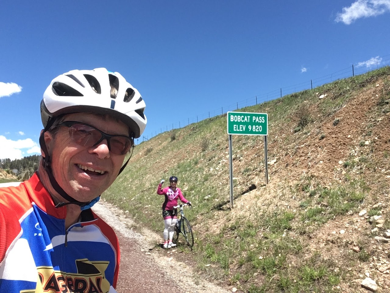
Top of Bobcat Pass on the Enchanted Circle from Taos, New Mexico

Beth on the Climb to Bobcat Pass, near Taos, New Mexico
Since we were still nearly 1000 feet above
Taos and the wind was blowing in the direction we’d be headed, we thought it
would be an easy run into town.
Unfortunately, as we have been finding out nearly every day, the last 25
miles of these rides is rarely easy all the way. “You’ve got a bunch of big hills coming as
you ride south out of town” said the woman at the Questa Visitor Center when
Beth asked about the road. She was not
exaggerating. They were big and there
were a bunch. On the flip side, we were
rewarded with some fast downhills (49+ mph) and there was indeed a tailwind
helping us along. We had an uneventful
ride through the busy streets in Taos, and finished this one at 101 miles with
big smiles on our faces.
Week 4 – Wyoming, Montana, Washington
From New Mexico we drove to Evergreen, Colorado where we
spent a couple of wonderful days with our college friends Fred and Marggi
Seymour. We did some hikes with Fred and
Marggi and enjoyed spending some well-deserved rest time before our next
push toward the northern Rockies.
Start Point
|
Date
(2019)
|
Riding
Distance (miles)
|
Elevation
Gain (ft)
|
Average
Speed (mph)
|
Max
Speed (mph)
|
High
Temp
|
State
Century
|
Laramie, Wyoming
|
6/11
|
100
|
5459
|
15.6
|
49.2
|
70
|
#42
|
West Glacier, MT
|
6/15
|
100
|
6909
|
14.3
|
35.7
|
70
|
#43
|
Spokane, WA
|
6/17
|
102
|
5331
|
14.4
|
49.9
|
80
|
#44
|
Wyoming – Cheating the System - Snowy Pass, Medicine Bow Mtns.
We stayed in Laramie with our friend Evan Johnson and his
wife Fawn. Evan had lived in Willimantic
while he was a graduate student at UConn and he’d joined us on previous running
and cycling adventures in the Nutmeg State.
He’s now professor in exercise physiology at the University of Wyoming
and is looking forward with Fawn to becoming a parent in the fall.
Knowing that Evan is a super-fit 37-year old, we had
suggested a few months ago that he plan us an epic 100-miler that made use of
Wyoming’s mountainous landscape. His required participation in this epic 100-miler was not negotiable. Evan seemed a little trepidatious about
riding 100 miles, particularly of the possibility of getting his butt kicked by
woman old enough to be his mother, but Evan is a good sport and always up for
an adventure, so he relented and charted us a route over Snowy Pass in the
Medicine Bow Mountains west of Laramie.
To keep things interesting, Evan had planned a point-to-point route on
Wyoming Route 130 from Walcott to Laramie that required a 100-mile shuttle of
the three of us and our bikes over Snowy Pass and out into the plains on the
other side.
When I looked at Evan’s west-to-east one-way route, which
involved a 3500-foot vertical climb to the top of Snowy Pass from his proposed
start point in Walcott, WY, I began to concoct a devious plan. “How’s about we have your friend drive us 50
miles out to the top of the pass. We’ll
then start our ride with a 25 mile downhill going west, turn around and climb
the pass once going east with the legendary Rocky Mountain easterly wind at our
backs, and then cruise the last 50 miles from the top. That way we’ll get to
drop twice as far as we climb and have a tailwind for our last 75 miles”. Evan didn’t have to be asked twice as this
meant he only had to keep up with the 59-year old mother of two for one major
climb and not two. Beth was asked
whether this approach violated any of the provisions of her 50-state century
quest guidelines. After consulting with
the rest of the governing committee, which was limited to her husband, Beth and
the committee determined that a net 3500-foot drop and a 75-mile finishing
stretch with a tailwind would be just fine.

With our Friend Evan Johnson Boarding the 6:15 AM Shuttle, Laramie, Wyoming
Afternoon thunderstorms are an almost daily occurrence in
the Rockies this time of year, so we woke up early and hopped on the one-way
shuttle provided by Evan’s friend Jason to the top of the pass at 6:15 AM. By 7:30 we were standing with our bikes in a
very snowy parking lot at 10,600 feet with the soaring peaks of the Medicine
Bow Mountains before us. The road crews
had finished clearing the snow from the pass only a week before, and high snow
banks on either side of the road added to the dramatic effect. Since we were starting at the top and would
be coasting downward 3500 vertical feet in sub-40-degree temperatures, we were
bundled up pretty well. We dashed down
the hill with the hopes of getting into warmer weather, and eventually our
prayers were answered as we descended out of the snow and into the dry
plains. The winds from the west were
picking up as we approached our initial turnaround at 25 miles near Walcott,
which was fine with us because we were about to get those winds at our backs
for the remainder of the ride. We
stuffed a bunch of clothes in the back rack I had installed on my Cannondale
for this occasion and started our 3500-foot climb back to the pass. We made it over the pass in fine form, with
Evan keeping up with the two elders quite admirably, although he did spend some
time whining about knee pain. His older
arthritic colleagues suggested he get used to it as he had about another 50
years to go before he found relief from joint pain (if you know what I
mean). He informed us at the 45-mile
mark that he had already logged more miles that day than he’d logged any single
day in the last five years. We then felt
bad about his knees and our dismissive comments.

Launching our Wyoming Ride - Snowy Pass, Medicine Bow Mountains (34 degrees!)

Ready for a Chilly 3500' Descent from 10,600 feet

Medicine Bow Mountains, west of Laramie, Wyoming

Beth and Evan Cresting Snowy Pass on the Return Trip, Wyoming
We stopped in the Town of Centennial at 65 miles for lunch
after a screaming 3000+ foot drop from the top of the pass. After that we were onto the open plains with
strong tailwinds that rocketed us back to Laramie often seeing 30 mph on the
flat roads. The 16.0 mph that was on our
odometers as we rolled into town was the fastest average we’d experienced on
the trip on single bikes. A tailwind and
3500-foot net descent will do that.
Montana – To the Sun and Back (Twice)
From Laramie we drove northwest to Jackson, Wyoming, which
surpasses Taos as a destination for the rich and famous. I provided Beth with some fiery entertainment
at dinner by accidentally ingesting the majority of a large habanero pepper
before realizing that this item on my plate was not intended for human consumption
and was definitely not the mild yellow pepper of the Big Y variety that I
expected.

Teton Mountains, Jackson Hole, Wyoming
We passed on the pricey Jackson hotels in Town and camped in
the Gros Ventre National Park Service campground outside of Town. At the campground we had an interesting chat
with a weathered Australian guy who was taking an evening break on a motorcycle
trip that had originated in Panama. He’d
passed through all of the Central American countries where most gringos fear to
go. While negotiating Nicaragua he encountered an informal road block that had
been set up by some local residents to separate motorists from their cash. The machete wielding attendant asked him for
the equivalent of 30 dollars. “I’m not giving you $30”, he said, “How about
$3”. “Sounds good”, said the man with
the machete, who then took the cash and happily sent him on his way.
From the Tetons we followed a line of Winnebagos on to Yellowstone
for a little sightseeing. We had to
deflect from our original plan of driving past Old Faithful because VP Mike
Pence and the Secretary of Interior were visiting the park that day to tell the
world how much President Trump loves nature.
We were impressed at the lengths to which the present administration is
willing to go to personally annoy us, Mr. Pence’s visit being only the latest
example. Our alternative trip up the
east side of the park featured sightings of hot springs, grizzlies, black bears,
and bison, as well as a hike along the rim of the Grand Canyon of the
Yellowstone River.

Grand Canyon of the Yellowstone, Wyoming
With all the Yellowstone campgrounds full, we continued into
Montana and spent a night in the mining town of Butte, where they’ve pulled 53
billion dollars’ worth of copper out of the ground over the years and have
built a museum to commemorate the 2300 miners that have met their maker during
that process. Then we were on to
Whitefish, Montana, the jumping off spot for our ride at Glacier Park, which
would be State Century #43.
We stayed in Whitefish with one of my college roommates,
Jeff Mow, and his wife Amy. As luck
would have it, Jeff is the Superintendant for Glacier Park, and someone who was
intimately familiar with the area. Jeff
had informed me a few months earlier that the iconic mountain road through the
park, the Going to the Sun Road, would be open only to bicycles for the weekend
prior to the official opening of the road on June 22, as long as snow clearing
had been completed by that date. This
was not a snowy year in Montana, and they had completed the snow clearing about
a week before we got there.
The road stretches 50 miles from the western entrance gate
to St. Mary’s on the east and climbs 3500 feet up to Logan Pass at an elevation
of about 6600 feet. While this is not
particularly high from a Rocky Mountain standpoint, it’s an extremely snowy and
alpine setting due to its latitude, which is only 30 or 40 miles south of the
Canadian border. There’s one spot where
it’s not unusual for the road crews to have to clear a drift that’s 90 feet
high to get the road open.
It’s about a 25-mile ride up to Logan Pass from the western
entrance, which created an issue for us because a ride to the top and back
would only give us half of the 100-mile distance we needed for our quest. Our solution was to ride up to the top and
then down the other side to the Town of St. Mary’s, which was a perfect 50
miles one way from the western entrance.
Once in St. Mary’s, there was the small issue of re-scaling the 3000 vertical
feet back to Logan Pass, but I assured Beth that the nine century rides she’d
already completed in the past four weeks and her altitude training made her
well suited to the task. I didn’t really
know this, but it sounded good at the time.
Our departure up the mountain was delayed by 30 minutes
because the alarm on my watch was effectively sound-proofed by a pillow that
resided on my wrist. By the time we
finally got to our jump-off spot at the eastern entrance at about 7:00 there
was already a stream of cars with bikes headed to the section of road which is
closed to motor vehicles. The first part
of the ride, along Lake Macdonald, was open to vehicles, but when we got about
15 miles from the entrance there was a gate across the road at the Avalanche
campsite. The vehicles were parking and
disgorging hundreds of cyclists eager for the once a year chance to ride the
road without fear of being pushed over a cliff by a lumbering motorhome.
The 3500 vertical foot climb to the top of Logan Pass is big
challenge, and we assumed that participation in this event would be limited to
those on 16-pound carbon race bikes powered by 25-year old legs. In this assumption we were incorrect. There was every type and style of bike
imaginable. We saw 12-year olds, we saw
80-year olds, and we saw people carrying their dogs in baskets. In this part of the world, the bike ride up
Glacier before the road opens to cars is a community celebration, and everyone
wants a part of it. 
Random Woman and Her Dog - Logan Pass, Going to the Sun Road, Glacier Park, Montana
About 10 miles from the top of the pass the grade kicks up
and you start the serious climb. The
engineering that went into this road, which was built in the 1930s using
Civilian Conservation Corps labor, is remarkable. It’s literally hacked into the side of a
cliff, and an excursion off the side of the road would reward you with a
downward flight of several hundred feet before you hit something solid. Between you and that downward flight there’s
typically an eighteen-inch high stone wall, which would give you a nice launch
off your bike if you ever had the misfortune of encountering it. The views are so spectacular it’s hard to
believe they’re even real, with sheer cliff faces punctuated by snowfields and
towering waterfalls for the upper portions of the climb.

Beth Climbing Logan Pass from the West - Glacier National Park, Montana


Climbing Logan Pass from the East Side (St. Mary's) - Glacier Park, Montana

Beth Riding Through The Big Drift East of Logan Pass, Glacier Park, Montana
Snow can be as deep as 90 feet at this location in the Spring
Grades on the climb were a steady five to seven percent,
pretty gradual by our eastern Connecticut standards, and as we pushed on up the
hill, we realized that we weren’t even needing our lowest gears. At one point, while I was feeling quite full
of myself for my climbing prowess, I heard a buzzing of knobby tires coming
from behind me at a solid pace. A young
woman then passed me on a fat bike. This
was remarkable to me not because she was a woman (I’ve gotten very used to
being passed by women) but by the fact that she had a child on a bike seat
behind her and she was towing a second child in a trailer. I quickly estimated the weight of her rig –
120 pounds for her, 40 pounds for her kids, 40 pounds for her bike, and another
30 pounds for the trailer and rack, for a total approaching 250 pounds. A short time later her husband pedaled up
next to me, “You don’t need to feel too bad”, he said, “it’s got a battery
assist feature. I saw you looking over at them and thought you ought to know”. Whew.
Beth and I made it to the top in good shape, and joined a
few dozen other riders for our selfies in front of the Logan Pass sign. We then did something we saw nearly no one
else doing, we went over the top and down the other side. By that time the top of the pass was in a
cloud, and the 44-degree wet air made for a distinctly chilly descent. The highlight of our ride down to St. Mary on
the east side was the sighting of a bear grazing in some shrubs on the side of
the road with her cub perched in a nearby tree.
Jeff had informed us that the Glacier region is home to approximately
1000 Grizzly Bears, the highest concentration of Grizzlies on the planet. With that many Grizzlies, encounters with
humans are inevitable, and Jeff had given me a large container of bear spray
which I had in my Camelback, “just in case”.
Our encounter with the bear on the side of the road did not constitute
such a case, so thankfully the bear spray remained in its container. I did talk to a guy on the way up who
admitted he’d accidentally sprayed himself I the face with his bear spray twice
this spring, something he suggested we try to avoid.
After a quick bite at the bottom in St. Mary’s we did a 180
and started the climb back up the hill.
As we climbed back into the snow from the east, we noted some dark storm
clouds gathering to the west, but with our car on the west side of the
mountains we didn’t have a lot of alternatives for getting back. Just as we went over the top of the pass, we
felt the first rain drops. Then a lot of
additional rain drops, and then a deluge as we descended. Many of the riders who had started down were
now hunkered under overhanging cliffs trying to get out of the rain. We elected to keep dropping in an attempt to
get to some warmer temperatures.
Remarkably, the riders that were heading up the hill just kept coming
despite the deteriorating weather. Many
of them were wearing cotton t-shirts and no jackets and we wondered about how
the rest of their day was going to go. Once down to the bottom of the mountain
the sun returned, and we enjoyed a flat 20-mile ride back along Lake MacDonald
with a tailwind.
The rides over the snowy passes in Wyoming and Montana were
the most exhilarating and rewarding of our trip and both of us ranked them at
the top of the list.
Washington – it’s on the left side of the map
We said goodbye to our hosts Jeff and Amy in Whitefish the
next morning and pointed the bug-splattered deer-damaged warning-light-flashing
Dodge Caravan without a back door west toward Washington. Along the way we stopped in Wallace, Idaho,
and decided we’d return there in a few days for Century #45. Upon arriving at our next destination in
Spokane, we found the campground we’d selected was full, so we selected option
2, a cheap motel on the outskirts of town.
We went to bed early for an early morning start.
“Who is this woman and what has she done with my
not-a-morning-person wife?” were my first thoughts when someone purporting to
be Beth woke me up at 4:00 AM to get ready for our Washington ride. The weather forecast was for temperatures in
the high 80s and Beth was looking to avoid riding in the heat, resulting in the
pre-dawn mobilization. (Note from Beth: I have not changed my watch from
eastern time, so according to my watch, it was a reasonable 7:00 am.)
I had originally mapped out a route about an hour drive
north of Spokane, but we were both getting sick of driving, so Beth googled
“Century Rides Spokane” and we were able to get a map for the “Lilac Ride”, an
organized 100-miler that had gone out of Spokane a month earlier. We went to the advertised start location of
the ride at Spokane Falls Community College and were greeted by scary “Permit
Only” parking signs. We went next door
to the Unitarian Church where there were more scary signs indicating that we’d
be towed if we even thought of parking there.
We parked there anyway, and Beth put a note on the dashboard saying
“We’re Unitarians from Connecticut that are parked here to do a bike ride. We’ll be back to the car by 3:30 and will
remove our car at that time. Please
don’t tow us”. And with that, we locked
up the van with our valuables inside and were off on our two-wheeled Washington
adventure wondering along the way if the Unitarians of the Spokane variety
would believe our sign and take pity on us.
The Washington ride started with a wonderful 10-mile section
on the Centennial Trail along the Spokane River, which tumbles through a canyon
at the edge of town. After about 10
miles along a relatively busy State highway the road headed into the less
populated countryside of eastern Washington via Corkscrew Canyon Road, which
lived up to its scenic moniker. Beth and
I loved the countryside of eastern Washington, which was rolling and
varied. At a little over 50 miles we
reached the turnaround spot of our ride in the Town of Reardon, which was the
furthest west we’d reach on the trip before heading back east. We celebrated with a couple of selfies in
front of their mule-themed municipal décor, and ate some breakfast burritos at
the local diner.

Our Furthest West Point on the 2019 Trip - Reardon, Washington

Seventy Miles Down, Thirty to Go - West of Spokane

Canola in the Sunshine - Washington State

Beth Rolls Through the Undulating Terrain of Eastern Washington
On our way back to Spokane we spotted some cyclists on the
side of the road and stopped to talk.
They were from a loosely organized cycling group in Seattle called
“Goosebumps” and were on their annual club excursion. “We’ll be having a happy hour in Room 209 at
the Hampton Inn at the Airport if you’d like to come join us after your ride”,
they said. “We just might”, we
said. A few hours later, after we’d had
a good conclusion to our 100-miler back to our untowed car, we found ourselves
at Room 209 in the Hampton Inn with a group of 15 or so folks that seemed a lot
like us. Stories were told, beer was
consumed, and we went on to have a wonderful dinner with this group, which we
had no doubt we’d belong to if we lived in the top left corner of the U.S.
map. Our chance encounter with the
Goosebumps club and the good time we had with them was just the latest example
to us of how important it is on a trip like this to allow your plans to be
fluid and to embrace the challenges, unforeseen situations, and chance
encounters that arise along the way.
Week 5 – Idaho
Start Point
|
Date
(2019)
|
Riding
Distance (miles)
|
Elevation
Gain (ft)
|
Average
Speed (mph)
|
Max
Speed (mph)
|
High
Temp
|
State
Century
|
Wallace, Idaho
|
6/19
|
103
|
1742
|
15.4
|
24.4
|
60
|
#45
|
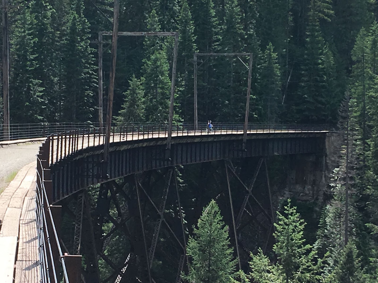
Idaho – Century Prelude on the Hiawatha Trail
Our fist ride got off to a rough start. The Hiawatha Rail Trail on the Montana side
of the Montana/Idaho border near Interstate 90 makes use of the last
transcontinental railroad line to be built in the U.S. (1908) and over its
14-mile length features a dozen tunnels and another dozen or so high trestles
as it tries to maintain a grade of less than 2 percent as it passes over and through the Bitterroot
Mountains. The trail is operated as a
concession and the start is actually about 10 miles from where you buy your $15
ticket for the experience. Our research
on the trail was not comprehensive, and we had assumed that the trail was paved
in the same manner as most of the other rail trails we’d seen in the area. “Oh yes, the trail is completely paved and
you should have no problem” said the young woman at the reservation desk, who
had worked there a total of two days.
With confirmation that the trail was paved, we rented
the necessary clip-on lights to negotiate the tunnels. I was surprised that the lights we were given
were both covered with a layer of fine-grained light brown mud. I’ve done a lot of riding on Connecticut’s
gravel rail trails, and a trail has got to be pretty darn muddy to coat
something mounted on the handle bars with mud.
“Is the trail muddy?” I asked the freshly minted woman behind the desk. “It’s a little muddy in the first tunnel, but
you’ll be fine” she said. I wasn’t sure
how a paved rail trail could be muddy, but I trustingly took the lights and we
drove the 10 miles to the trailhead with our shiny road bikes in the back of
the car. When we arrived at the entrance
to the trail, known as the East Portal, we observed a gravel path emerging from
a tunnel in the mountain. There was not
a road bike in sight and the bikes and bodies emerging from the tunnel were
embellished with an impressive layer of pasty mud. “Is the trail paved?”, I asked the guy taking
tickets. “Oh no, what would have given
you that idea?” he said. “It’s a gravel
trail, the first tunnel is really wet, and you’re going to get muddy. Are you sure you want to ride those shiny
bikes with those skinny tires?”

Beth Enters a 1.7 Mile Long Railroad Tunnel
Hiawatha Trail, Bitterroot Mountains, Western Montana
We ended up renting a couple of rusty comfort bikes from the
guy, which required an annoying 20-mile car trip back to the spot where they
sell the tickets. Once that was worked
out, we were ready to go. The initial
tunnel at the start of the trail is the longest of the route and extends 1.7
miles. It was a slight down-grade in the
direction we were going. With tunnel temperatures
in the mid 40s and water dripping off the ceiling there was a distinct
chilliness to the start of the ride, so we did what most cyclist do when
they’re cold - we pushed the pace to generate some body heat. The wet trail, our knobby tires, and our need
for speed resulted in dual rooster tails of mud splattering pretty much every
square inch of our bodies by the time we exited the tunnel, particularly our
backsides where we could feel the layer of wet mud seeping through our lycra
and into the various epidermal nooks and crannies that reside beneath that
lycra.

Mud Embellishment on the Hiawatha Trail
With dampened bodies but undampened spirits, we continued
on, delighting in the fact that our shiny bikes remained locked in the
car. The balance of the 14-mile route
was the most spectacular trail I’ve ever ridden on with two wheels. The trail clung to the side of steep valley
walls with an average of about one high trestle and one tunnel every mile. Interpretive signs every half mile or so were
interesting and informative. This trail
needs to be on everyone’s life list, particularly if you can arrange to ride
someone else’s bike!

View of a High Trestle that Awaits Us - Hiawatha Trail, Western Montana

Beth about to Enter Another Tunnel on the Hiawatha Trail
Hiawatha Trail - Western Montana

Hiawatha Trail - Western Montana
We had planned to turn around at the western terminus and
ride the 14 miles back, but when we contemplated a 14-mile uphill return trip
on rusty “comfort bikes”, considered the fact that we’d be riding 100 miles the next
day, and saw everyone else happily loading their bikes onto a shuttle bus, we
decided that today was a good day to be wimps and we joined the throng for the
uphill return trip in the comfort of a school bus.
Idaho Century – Trail of the Cour d’Alenes
This one was supposed to be easy.
The Trail of the Cour d’Alenes is a 70-mile paved rail trail
that runs from Mullen to Plummer, Idaho in Idaho’s panhandle region just south
of Interstate 90. We hopped on the trail
near its eastern terminus in Wallace and pointed our bikes west, for a 100-mile
out and back. Like the Hiawatha Trail,
the Trail of the Cour d’Alenes is in the Rail to Trail Conservancy’s top 25
rail trails in the nation. The western
section of the trail passed through several mining towns including the town of
Smelterville where, you guessed it, they smelted the hell out of a mountain of
crushed rock to liberate its mineral wealth – primarily copper, zinc, lead, and
silver. The emissions from the
operation settled throughout the valley, resulting in ubiquitous soil
contamination in the area and one of the largest Superfund sites in the country. The paved rail trail and the gravel sub-base
beneath it protect users from the toxins in the soil and are part of the final
remedy the mining companies funded to pay for their past sins. Unless you knew this by reading the signs,
you’d pedal along on your merry way through Idaho’s beautiful countryside
oblivious to what’s under your tires.

Easy Outbound Roll on the Trail of the Cour d'Alenes, near Smelterville, Idaho

Trail of the Cour d'Alenes - Wallace, Idaho
We had a strong wind in our face on this ride right from the
start, but we didn’t mind it because we knew (or at least I knew) that we’d
have a tailwind of the same force for the last 50 miles and the forecast was
for clear weather all day. Beth was
unwilling to listen to my optimistic forecast, having been burned multiple
times on this trip in similar circumstances.
The sights got nicer as we went, with the trail running along rivers,
lakes, and large wetland areas. We
spotted lots of waterfowl and a bald eagle along the way as rewards for our
efforts. The habitat also seemed perfect
for the moose to round out our list of animals spotted along the way but we saw
none on the trip west. We were in high
spirits when we rolled into our turnaround location at the 50-mile mark in
Harrison. Lunch was at a restaurant
called One Shot Charlie’s where we each had a reuben sandwich and no
shots. Beth and I talked about the great
luck we were having with the weather and I again waxed on about the 25 mph
tailwind we’d enjoy on the return leg.
Sometime around the end of our lunch, Beth looked out the
window and realized that there were dark storm clouds gathering and coming our
way fast. We quickly paid the bill,
hopped on our bikes, and tore off down the trail with 50 miles ahead of
us. Neither of us had brought a raincoat
because the forecast that morning had been for ZERO percent chance of
precipitation. After about a mile Beth
said “Guess what, we didn’t remember to fill our water bottles”. With few options for water along the way, we
were forced to go back to the restaurant to get the bottles filled. Meanwhile, the clouds grew darker, and
closer.
Back on the trail again, we dashed eastward, with Beth in
the lead by a few hundred yards. She
suddenly stopped in front of me, pointing across a wetland. A cow moose had stepped out of the woods and
was feeding on some water lilies. Wanting
to memorialize this sensational moment, I reached into my back pocket where I
keep a Ziploc bag containing my phone, some money, and a credit card. “Uh Oh”, I said to Beth, “I left my credit
card back at the restaurant”. While Beth
remained with the moose, I turned around again for my third trip to the
restaurant that day. Meanwhile, the
clouds grew a little darker and a little
closer.

Moose Chomping Water Lillies
Trail of the Cour d'Alenes, Harrison, Idaho
I picked up Beth at the moose site, and we high-tailed it
eastward, with the black clouds moving right along with us. The anticipated tailwind was cooperating, and
we flew up the trail at a quick pace, watching the riders coming the other
direction wobbling along against a headwind with grim determined faces as they
tried to get back to their cars before getting pummeled by the impending storm. For 10 miles or so on the return trip the
tailwinds were pushing us along at speeds consistently above 20 mph and life
was good. Then it wasn’t.
The first drops hit us at about the 60 mile mark. By 65 miles it was raining steadily. The thermometer on my Garmin said it was 45
degrees. We were not wearing raincoats,
we had 35 miles to go, and the tailwind was starting to wane. We started seeing other riders hunkered into
any kind of shelter they could find. I
suggested the possibility of joining them, but Beth responded “We’re already
wet, what good is stopping going to do us?”.
She had a point, and we rode on, pounding out what we both agreed was
our strongest effort to date.
Desperation will do that.
Always looking to make helpful supportive comments to her
flagging spouse, Beth said to me at one particularly cold wet point “Only two
more hours of this and we’ll be done”. I
thought to myself “Marathoners run marathons in a little more than two hours –
my toes are cold, my fingers are cold, and this is going to be a
suck-fest. Plus, I think my wife may be
tougher than me”. Somewhere in there I
saw a flag blowing the wrong way – the wind had changed course 180 degrees and
was now in our face. Despite my unspoken doubts about our chances of survival,
the miles went by, we didn’t die, and eventually we made it back to town at the
103-mile mark feeling a bit chilled but quite rugged indeed. Lesson for the day – forecasts lie. Always bring a raincoat when you’re riding in
the Rockies.
Week 6 – The Upper Midwest
Start Point
|
Date
(2019)
|
Riding
Distance (miles)
|
Elevation
Gain (ft)
|
Average
Speed (mph)
|
Max
Speed (mph)
|
High
Temp
|
State
Century
|
Kulm, North Dakota
|
6/26
|
105
|
2815
|
15.5
|
28.2
|
75
|
#46
|
Fort Sisseton,
South Dakota
|
6/28
|
100
|
3360
|
17.0
(tandem)
|
38.3
|
80
|
#47
|
Brainerd, Minnesota
|
6/30
|
100
|
1040
|
16.1
|
24.7
|
80
|
#48
|
Cable, Wisconsin
|
7/2
|
105
|
3231
|
16.0
|
32.9
|
85
|
#48*
|
Note (*): Beth had completed a ride in Wisconsin previously but John had not, so the completion of Wisconsin added one to John’s total to get him to 48 states completed. Beth was already at 48. The official count up to this point has been based on Beth’s total. John and Beth were both at 48 states completed after Wisconsin.
Our riding took a bit of a hiatus between weeks five and six
as we made our way from Idaho to the eastern Dakotas, with stops along the way
to see the things that one must see when one travels the east-west route across
the top left quadrant of the U.S. map.
For us those things included Devil’s Tower in northeast Wyoming, the
Black Hills and the Badland areas of South Dakota, and of course, Wall Drug, in
Wall, South Dakota, an American icon that must be seen once but not more than
once in a lifetime by every American citizen.
At each of these spots tour buses discharged throngs of tourists, which
encouraged us to get back to our roads less traveled.

Devil's Tower, Northeast Wyoming
Our non-cycling day in the Black Hills included a 10-mile
hike to South Dakota’s highest point.
Black Elk Peak, at 7700 feet or so, boasts that there’s no higher peak
in an eastward direction until you reach the French Alps. While we were on top of Black Elk Peak we ran
into a trail runner named Gary Harrington, a 59 -year old originally from Keene,
NH. For the last four years he has been
criss-crossing the country doing ultra-marathons, including several 100 mile
trail races. We compared notes and realized
he knew several people that we knew from the trail running circuit. Along the way he has scaled the highest point
in every state, which explained his presence at the summit of Black Elk
Peak. The “high pointer” list, as it’s
called, captured our imagination, and we thought about our own achievements for
the high pointer 50-state list, which includes a small but growing number of states – so far
MA, NH, ME, OK, SD, NY. Might this be
our next quest? Hmmm . .

Encountering a Friend of a Friend - Black Elk Peak, Black Hills of South Dakota
Our stay in the Black Hills was in the town of Hill City,
which provides access to the Mickelson Rail Trail, a gravel-surface trail which
runs about 100 miles through the Black Hills Region. There are several bike-related businesses in
town and my sister Susan and her husband Peter had signed up to have their
bikes and bodies shuttled 50 miles to the town of Deadwood so that they could
do a one-way ride back to our campground.
They gave the trail high marks, as does the Rails to Trails Conservancy,
which includes the trail in their top 25 Rail Trail Hall of Fame. Beth and I skipped the Mickelson Trail
because of its incompatibility with our skinny tires and shiny paint jobs.
North Dakota – Cycling through The Duck Factory
We had originally planned to do our two Dakota rides in the
western badland areas amongst the buffalos and dissected topography that define
the landscape in that part of the world. That plan was scrapped after we
realized that western North Dakota is rife with big trucks moving oil around,
and that western South Dakota is awash with big RVs hauling tourists with
questionable driving skills around. As
an alternative, we motored to eastern North Dakota and stayed in a little town
named Kulm, situated only a few miles north of the border it shares with its
Dakotan sister to the south.
My brother-in-law Peter’s family owns a three-room house in
Kulm that Peter’s brother bought a few years ago for $2,000. Yes, $2,000 still gets you a house in some
parts of the country. We relied on Peter
to map out our routes in the Dakotas, and he had done just that. Unfortunately, the North Dakota route he
originally proposed had zero spots to get water in 100 miles. “We’ll be fine”, I said. We can fill our camelbacks and drink a lot of
water before we leave”. “Don’t be an
idiot”, Beth said. “I’ve been drinking six water bottles per ride and if we run
out of water on these lonely roads we’re screwed”. Recognizing the marital conflict that he had
created, Peter quickly recommended another route heading north from town that
would hit a few small towns with convenience stores. Beth was satisfied, and I avoided another
potential marital conflict of my own making.

Mooching Some Free Lodging from John's Sister Sue and her Husband Peter
Kulm, North Dakota
We fell in love with the North Dakotan landscape as soon as
we left town. The last ice age left the
landscape dotted with “prairie potholes”, the equivalent of New England’s
glacial kettle holes. They were formed
10,000 years ago when the last blocks of glacial ice melted out, leaving divots
in the landscape. Those topographic
depressions typically fill up with water, and that water attracts a myriad of
waterfowl, some of which we recognized and some of which we didn’t. There was a wide variety of ducks as well as
coots, grebes, cormorants, and the most surprising to us – white pelicans,
which come north to mate from southern locales.
Over the course of our 105-mile ride in North Dakota, we went by perhaps
100 of these ponds, and each time we’d go by one there would be an explosion of
wings and water as our feathered friends launched themselves to flee the
unfamiliar two-wheeled hazards that were coming up the road. The plethora of wildlife of the winged
variety has earned North Dakota the title among hunters as “the duck factory”.

"Prarie Pothole" - Glacial Kettle Lake near Kulm, North Dakota
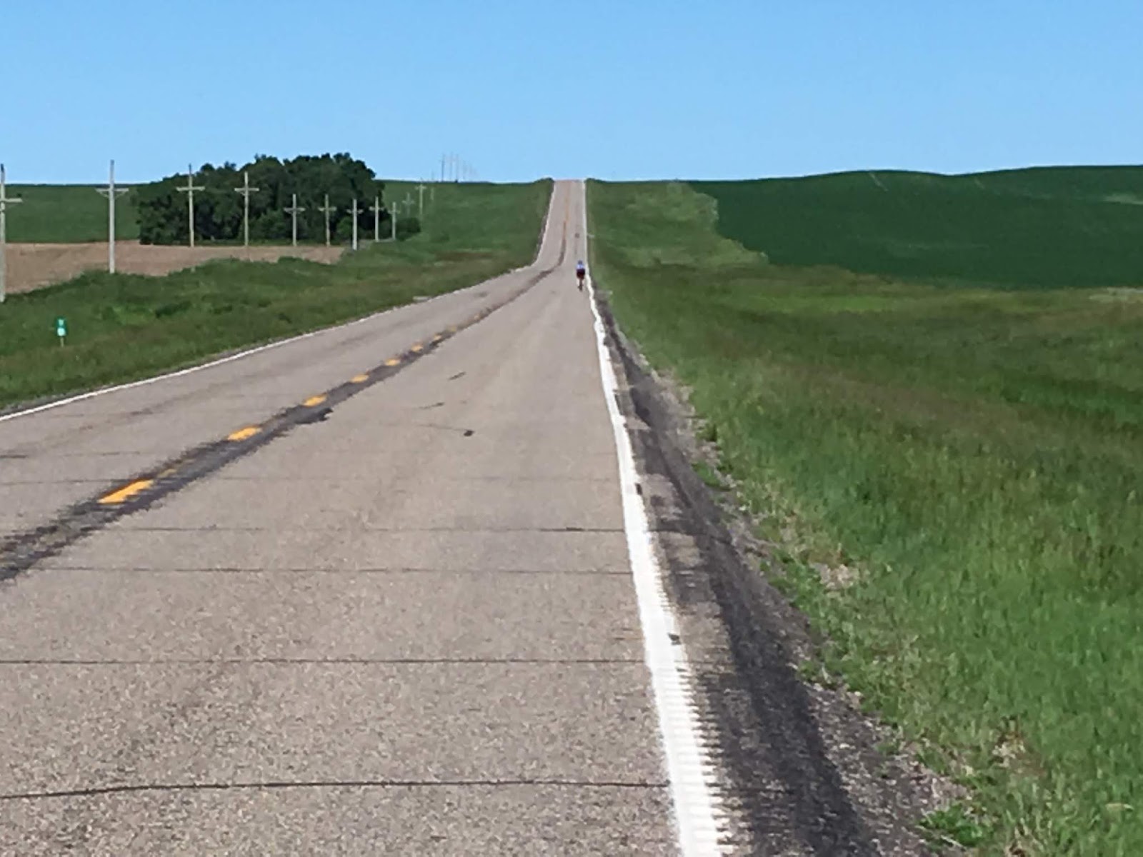
Lonely Highway near Kulm, North Dakota (see Beth for Scale)

Then and Now - Gackle, North Dakota
North Dakota is sparsely settled, and it’s not uncommon to
ride 10 or even 20 miles between towns.
Along our route we passed through four small towns – Jud, Gackle,
Streeter, and Freedonia. We were
saddened to see the struggles we’ve seen in small town America repeated in each
of these towns. The first thing you
notice as you roll down the main streets is that the businesses that occupy
store fronts are almost all closed.
There’s no one walking around, very little traffic, and lots of empty
parking spots. The second thing you
notice is that while there is a school building, in many cases the school is
closed due to dwindling enrollment. Each
of the towns we visited had a well-maintained town park with beautiful
playground equipment for children that just weren’t there, and probably won’t
be coming back any time soon.
When we stopped in Streeter to fill our water bottles, we
had a conversation with the 16-year old girl behind the cash register. We had noticed a large shuttered 1920s era
school when we pulled into town – now a decrepit wreck of a building with
broken windows and a crumbling façade.
The cashier confirmed for us that the school had been closed for many
years due to low enrollment. Children
now had the choice of going to school in Gackle, 15 miles away, or another town
located 50 miles away. She attended the
K-12 school in Gackle, which had a total enrollment of 100 students with a
graduating class of 4. She explained
that the only jobs in town were at the market (the job she had), or at the ag
store. Those children that don’t follow in their parent’s footsteps to run the
family farm leave town, and it’s clear this exodus had been the trend for more
than a generation. We left Streeter as
we’d left so many towns we’ve visited across the country, wondering what the
future holds for these once-thriving communities.
Abandoned School in Streeter, North Dakota
You don’t see a lot of cyclists on the lonely roads of North
Dakota, but we did run into one. Tom
from Texas was riding from Missoula, Montana to Bar Harbor,
Maine (he’d ridden from the west coast to Missoula last year). He was on a recumbent and his “sweetheart”
was driving along and meeting him each night with their camper. The route he was taking was one that was
recommended by Adventure Cycling, a group out of Missoula, MT that maps routes
for cross-country cycling excursions.
Little did we know when Peter drew a line on the map before our day
began that we’d be riding on a road that at least one group deemed to be one of
the best ways to cross the country. We
agreed with their assessment. Although
the shoulders on most of the roads in North Dakota are minimal, and there’s
often a rumble strip where you might normally like to ride, there were almost
no vehicles to contend with. We’d
typically get passed by a vehicle about once every five minutes and sometimes
much less frequently than that. Drivers
are used to contending with farm equipment, visibility is endless, and as a
result, drivers typically move their cars as far into the oncoming lane as they
can when they go by you. As they
approach from behind you hear them crossing over the center rumble strip, first
one set of tires then the other as they give you as much room as is feasible.

Tom From Texas - Spotted Outside of Streeter, North Dakota on his way to Bar Harbor, Maine
Beth and I greatly enjoyed our ride through the Duck
Factory. Beth declared this one to be
her “most pleasant” rides of the trip, in part because our bodies are now tuned
to the ritual of getting up early, banging out 100 miles, and then getting
ready for the next outing. It’s a far
cry from how we felt early in the trip when we were battling the headwinds of
Kansas and Nebraska on legs unfamiliar with the routine.
South Dakota – Descent from the Coteau de Prarie
We camped the nights before and after our South Dakota ride
at Fort Sisseton, a civil war era fort that had been erected by the Union in
1864 in response to Indian uprisings that were occurring in the territories
west of Minnesota. The fort was manned
for about 30 years and many of the original buildings are still present and
accessible. As the tour guide told it,
the fort never experienced an armed conflict with the natives because a group
of Indian Scouts retained by the Union was effective at cooling tempers and
negotiating an ongoing peace.Knowing that the South Dakota century would be fairly flat, we pulled the tandem out of the van for its first 100-mile excursion since Oklahoma. The main geographic feature of this ride was a descent and ascent of the escarpment at the edge of the “Coteau de Prarie”. Little known geographic fact about the Dakotas . . . most of the Dakotas are on a Plateau that’s about 600 feet higher than western Minnesota. The Coteau de Prarie is the dividing line between these two areas and it manifests itself as the abrupt edge of a plateau that drops 600 feet to the east.

Beth's view from the back of the Tandem off the east edge of the Coteau de Prarie, South Dakota

Descent of the Coteau de Prarie, near Sisseton, South Dakota
As we headed east off the edge of the Coteau de Prarie at the beginning of our ride we converted 600 vertical feet worth of
potential energy into 40 mph of kinetic energy.
At the bottom we rolled through flat agricultural land until we came to
Lakeville, SD, where we stopped so I could partake in my preferred morning
energy replacement fluid, Mountain Dew.
While I sipped the high fructose corn syrup treat, Beth and I struck up
a conversation with a farmer, one of the many conversations we’ve had with
locals throughout the country about what makes their community tick or not
tick, as the case may be. This farmer
grew corn and alfalfa on 5000 acres that he has in cultivation. He had the good luck that there was an
industrial-sized dairy farm in town that had 17,000 milking cows and he sold
his entire crop of corn and alfalfa to them each year. This model was different than what we’ve seen
in other towns where farmers sell their crop on the open market via the local
grain elevator. The farmer explained
that without the dairy farms there would be no Lake City, South Dakota. We thought about the dwindling population
we’d seen in the neighboring area and hoped that there will be enough people
around to continue drinking the milk and milk products that 17,000 cows
produce.
Our route took us into Sioux reservation land near the
half-way mark of our ride and we had lunch in the reservation town of Sisseton,
across the street from a Christian day school where dozens of kids played in
the front yard. The kids were a welcome
sight after the kid-drought of the previous towns, and the kids were probably
there at least in part due to the status of the area as a reservation. From there we turned back west and scaled the
hill back to the top of the Couteau de Prarie.
Once at the top we picked up a 25 mph tailwind that put smiles on our
faces and joy in our hearts. At times on
the return run I looked down and realized we were propelling our two-seater at
over 30 mph on flat roads despite the fact that we had 80 miles behind us. The tailwind pushed our
average for this ride up to 17 mph, our fastest tandem ride of the trip.
Minnesota – America’s Other Home of Paul Bunyan
Our trip to the alleged birthplace of Paul Bunyan involved
quick overnight stops with Beth’s college cross country team-mate Ruth in
Bloomington, Minnesota and with two Connecticut transplants, Dave and Meredith
Kloss, in Wadena, Minnesota. These
visits were the latest in a long list of people we’ve mooched lodging from as
we’ve cruised around the country and it’s been great to connect with friends we
haven’t seen in as many as 20 years.
We spent the night before our Minnesota ride near
Minneapolis, almost 150 miles south of our kickoff location in Brainerd. Weather forecasts we’d seen the night before
were for temperatures in the mid-90s with a heat index of 105 degrees and the
chance for violent thunderstorms. Not
ideal. To give ourselves the best chance
at beating the heat and storms, we got up at 4:00 AM and hit the road, hoping
for a 7:00 AM start to the ride.
At first light during our drive we were looking at angry
storm clouds forming in front of us and angry red and purple radar images
approaching from the west on our phones.
During the drive, the skies opened up and pelted our windshield with
rain. As we drove we were re-assessing
our plan and started talking about delaying the ride by a day. This idea was thwarted when we arrived at the
trailhead and realized that the rain had mysteriously stopped. Lacking any good excuses to sit the day out,
we pulled the bikes out of the car and got started on Century #48.
Everyone knows that Paul Bunyan was born and raised in
Maine. Everyone, that is, except folks
from the land of 10,000 lakes, who believe he was born and raised in Brainerd,
Minnesota. The people of northern
Minnesota are brazen enough to have named their favorite bike trail the “Paul
Bunyan Trail”, a direct afront to New Englanders who know the real truth. After considering boycotting the trail, we
decided to set aside our political differences with the Minnesotans and give it
a try. The trail stretches for over 100
miles between Brainerd and Bemidji, Minnesota, but because we needed to do an
out-and-back route we could only ride 50 miles out. 
Paul Bunyan Trail Out-and-Back, Hackensack, Minnesota

Paul Bunyan's Alleged Girlfriend in Paul Bunyan's Alleged Home State - Minnesota

Paul Bunyan Trail, near Brainerd, Minnesota
We made it exactly 15 miles before we heard the first rumble
of thunder from the dark cloud bank that was sitting directly in our path. Then another rumble, and then nearly
continuous rumbles as the storm gathered steam and we considered whether we
were looking at another wet rail trail ride like we’d had in Idaho. We pulled to the side of the trail in the
little town of Nisswa, which had re-purposed the original train station into a
chamber of commerce and rest room facility for the trail. For 15 minutes we ate peanut butter
sandwiches, fiddled with the weather apps on our phones, and fretted about our
future. Beth’s phone reported a severe
thunderstorm warning with chance of high winds and damaging hail. We fretted some more. And then nothing happened. It got a little brighter, and we started up
again.
Although the pavement was wet for much of our ride in
Minnesota, we experienced nothing but a few sprinkles and the clouds kept
temperatures in the 60s and 70s, a far cry from the forecast heat index of
105. A second thunderstorm cell passed
us by to the south. At this point we
felt like we’d been miraculously dodging thunderstorms, heat, and tornados for
our entire trip (except for that unfortunate 40-mile 45-degree stretch in Idaho
without raincoats).
Not wanting to tempt fate, Beth decided at some point on the
return trip to Brainerd that it was time to put the proverbial hammer down, and
she started pushing the pace. I noticed
that when I was in the lead we were going 18, but when Beth was in the lead we
were going 20. Lacking a leash or any
other means of physically attaching myself to her bike or person I was forced
to keep up, and for the first time on the trip I wondered whether I’d be able
to do that. Our dash to the finish
brought us in at just over 16 mph average for the ride which was our fastest on
single bikes up until this time. When I
down-loaded our ride into the Strava app, it indicated that for a certain 5
mile section from 90 to 95 miles, my 59-year old wife’s 20.3 average was ranked
as the second fastest time for the 70 or so women that had recorded times for
this segment. Amazing.

Billboard in Western Minnesota
We avoided political discussions with locals in America's Heartland
Wisconsin – Horsefly Capital of the Universe
We started our Wisconsin ride in the Town of Cable, which
I’d picked because it’s also the start of America’s largest and most famous
cross-country ski race, the Birkebeiner, 55-km of winter fun.
My sister’s reports of competing in the Birkebeiner have whetted my
appetite for challenge and I just might get my courage up before I check out of
this life to give it a go.
For Wisconsin we were joined by Andy Ferguson from
Minneapolis, who had ski raced with Beth and me during our Carleton College
days in Minnesota. Unlike us, Andy has
raced “the Birkie” several times and knew the roads in the area well. We managed to find an AirBNB cabin near our
proposed starting point in Cable and got up early for a foggy start to beat the
heat. Andy had not ridden over 50 miles
for a long, long time, but we convinced him that doubling this distance and
riding with two people that were in shape from riding 1500 miles in the last
six weeks would be good for his self-confidence. After listening to our primer on the wonders
of Chamois Butt’R lubrication cream, Andy lathered up, hopped on his bike, and
started up the road with us. We had a
smooth ride for the first 40 miles up Highway 63 to the Town of Ashland, and
Beth and I were happy to have an additional person in our paceline rotation. After a couple of quick photos on the
southern shore of Lake Superior and a banana muffin, we pointed ourselves back
south on a series of county highways that would return us to Cable.
With our Carleton College Ski Teammate Andy Ferguson, Lake Superior, Ashland, Wisconsin

Lake Superior, Ashland, Wisconsin
Prior to the trip I’d mapped out our routes and developed a
series of “cue sheets” to keep us on the right roads. Although we scrapped many of my proposed
routes when we saw what I was getting us into, the Wisconsin route was as I’d
originally proposed. We had planned to
stop in the town of Clam Lake for lunch at 66 miles. Unfortunately, my cue sheet, while nicely
formatted, was not entirely accurate.
When we got to 66 miles we were not in Clam Lake and I was not exactly
sure how far Clam Lake would be. “It’s
about 20 miles down that road” said one guy at a gas pump when asked. “It’s gotta be about 30 miles”, said another guy,
as he explained that there was nothing but national forest between here and
there. “I think they’re both wrong”, I
said, “I don’t think it can be more than 5 miles or so. It’s right here on the cue sheet I made
sitting at my computer in Connecticut”.
We filled our water bottles and headed down County Road M
toward what we hoped would be Clam Lake and lunch. Almost immediately we passed the last house
we’d see for a long, long way and entered the Chequamegon National Forest,
which we later learned is a sanctuary that the forest service established in
the 1940s to protect a particularly voracious variant of the Wisconsin
horsefly. I can now say without
reservation that the horsefly is not an endangered species in the State of
Wisconsin. Hundreds of them swarmed
around us as we headed south, quite effectively matching the 15 to 17 mph we
were making along the rolling roads. We
could shake them at speeds over 20 mph, but then they’d be right back once we
slowed down. They were unable to land on
us while we were riding, but woe to the hapless individual that stopped for a
bio break en-route. I did just that at
one point and donated a large chunk of flesh to one dime-sized individual that
chose my left ankle as his source of nutrition for the afternoon.
Much to our dismay, the guy who said it was 20 miles to Clam
Lake was spot on, and we pulled into our lunch stop at 86 miles feeling a bit
weary and undernourished. “How far back
to Cable?” we hesitantly asked the first person at the snowmobiler/ATV bar that
we had walked into. “It’s exactly 12
miles” said the guy at the bar. “86 + 12
= 98”, we calculated, pretty close to 100.
I told Beth and Andy he was wrong and that it would be more like 20
miles back and that we’d be looking at 106 miles at the finish. After all, I had it right there on my cue
sheet. They elected to believe the guy
at the bar. Needing some sustenance, we
ordered up some grilled cheese sandwiches and drank a couple of lemonades. These were consumed as we cheered on the U.S.
Women’s soccer team during their semi-final match against Great Britain. Adding to our cheers was the boisterous
applause from a crowd of well-fed leather-clad bikers and ATV enthusiasts that
had just emerged from the bush in need of malted sustenance.
On our ride south back to Cable it became quickly apparent
to Beth and Andy that my cue sheet was correct for the first time that day, and
that we’d be riding 20 and not 12 miles to the finish point. It was now about 85 degrees and Andy was
definitely “feeling it” (not in a good way), but he hung on nicely and we made
it back to town in good shape with 106 miles on the odometers. We managed to bring it in at 16.0 mph, tying
the land-speed record that we’d established in Minnesota two days earlier. Kudos to our friend Andy for putting himself
out there and hanging with the two of us, who after 1500 miles of centuries in
the past six weeks had some go in our legs.
Week 7 – Michigan
Start Point
|
Date
(2019)
|
Riding
Distance (miles)
|
Elevation
Gain (ft)
|
Average
Speed (mph)
|
Max
Speed (mph)
|
High
Temp
|
State
Century
|
Curtis, Michigan
|
7/4
|
100
|
2379
|
16.5
|
31.6
|
85
|
#49
|
I’ve had a lot of time to think about things as we ride
along each day and sometimes my thoughts turn to math. Example:
Total Pedal Strokes Completed During our Seven Week Trip = 7 hours per day x 17 days x 60 minutes per
hour x 70 revs per minute = 500,000 pedal strokes (per leg).
It’s amazing to me that certain biomechanical systems in our
bodies, such as our knees, can be used repetitiously that many times without
ill effect. Beth and I have been
fortunate that our bodies have held up throughout the trip and dare I say it,
actually thrived. We’re feeling very fit
now, and the pace we’ve been able to maintain has been increasing throughout
the journey. Taking a day off between the rides and giving ourselves a chance to
recover has been a winning formula that we’ve used throughout our ride with the
exception of back-to-back century days in Kansas and Nebraska in the second
week, which we both agree was one of the lower physical and mental points of
the trip.
When I’m not thinking about math on our rides, I’m often
playing a song in my head, typically prompted by something I’ve heard in the
last 24 hours or something that’s currently on my mind. REO Speedwagon’s “Riding the Storm Out” has
been a staple when the black clouds are threatening as they were nearly every
afternoon in the Rockies. Our final ride
to Lake Superior in Michigan was accompanied by Gordon Lightfoot’s ballad about
the stormy ending of the Edmund Fitzgerald, which as I remember it goes “The
legend lives on from the Chippewa on down to the big lake they call
Gitchigoomie. The big lake they say
never gives up her dead when the skies of November come early”. I may have those words wrong, but it really
doesn’t matter because it’s my own personal sound track and no one gets to
judge me. Beth doesn’t typically have a
sound track playing in her head, unless I endeavor to put one there, in which
case it is indelibly inscribed in her memory banks. As we traveled down a lonely road in
Michigan on our final day of riding, I shared with her what I believed to be a
touching ballad when I sang to her my rendition of Paul Anka’s musical
masterpiece "Having My Baby". You’ll
recall it goes something like this . .
.“Havin’ my baby, what a lovely way of sayin’ how much you love me”. Beth spent the next several hours looking for
her mental delete button and cursing my existence.
When we were planning for this seven week bike excursion,
Beth and I tried to think about all the things that could go wrong and to plan
for them. Some of them were easy to address
– we brought a pile of extra inner tubes and some extra tires (all of which got
used). Other things we knew we could manage along the way – like sunburn and
body hair. But one other category was
less easy to plan for – how would our relationship hold up after the trials of
living in close quarters for seven weeks and the physical and mental challenge
of getting on a bike every other day for 100+ miles, regardless of the weather,
our physical condition, or whether we just didn’t feel like riding anymore. Beth asked me on our final day whether I was
getting sick of this. The truth is, I wasn't, and neither was she. This was one of
the biggest surprises of this trip to us – we would have been fine to continue
at the pace we were going for several more weeks, or perhaps months. The health of our relationship was at the
core of what made this work, and I have isolated the two primary factors that
kept our relationship healthy as we made our way across the country and
back. Those factors are these, at least
from my perspective: 1) When one of the
couple feels strongly that something should be done, the other member of the
couple should go along with it, and 2) Never feel strongly about anything.
Michigan – To the Big Lake they call Gitchigoomie
Lake Superior is really, really big. Our previous ride in Wisconsin was on a
north-south route that turned around at the shore of Lake Superior. We then drove 250 miles east to the upper
peninsula of Michigan, where we once again traveled a north-south route that
turned around at Lake Superior. I was
struck by a factoid in the little brochure at the visitor’s center, which said
that Lake Superior holds 10 percent of the fresh water that’s retained our
planet’s lakes.
Michigan was just the latest example of the importance of
effective route planning, and I’ve gained new respect for the friends that have
planned some of our century routes in the past.
I had plotted out a 105 miler in Michigan that had a presumably scenic 20-mile
section that ran along the shore of Lake Superior. We’d gotten into the habit early in the trip
to stop at a visitor’s center or local bike store to ask them about the roads
we’d planned. “You don’t want to go that
way”, said the guy at the Michigan Visitor’s Center, “that’s 15 miles of
unimproved dirt road. I don’t even send
cars up there”. Seems the map I had been
consulting had gotten that particular detail wrong. So the night before our Michigan ride we
found ourselves in the familiar position of squinting at a state road map trying
to cobble together a route that was free of dirt roads and as free as possible
of traffic. As had happened seven previous
times on this trip, we were unable to find a 100-mile loop that fit the
criteria in this area, so we planned an out-and-back route from the little town
of Curtis where we were staying in the Upper Peninsula to the shore of Lake
Superior and back.
We got a 6:50 AM start to beat the traffic and heat, and
quickly gobbled up the first 20 miles, which included an eight-mile section on
Michigan Route 28, one of two major east-west roads on the Upper
Peninsula. From there we turned north on
Route 123 to the Town of Newberry and then took a smaller road the last 20
miles until we made a final left on a shore road at Lake Superior. We encountered the dirt road that the guy at the
visitor’s center had mentioned just 0.6 miles short of our required halfway
point at 50.0 miles, and made the difference by riding up the dirt road for a
quarter mile or so and turning around.
It was our only dirt road of the trip.
Perhaps next time we’ll bring the cyclocross bikes so we can do a bit
more exploring.

Traversing Our Only Dirt Road - Deer Park, Michigan

Beth Feeling Triumphant in Lake Superior - Upper Peninsula, Michigan
At our 50-mile turnaround point we gave our feet a break by
wading in the chilly waters of Lake Superior, downed a couple of peanut butter
sandwiches, and then started our return trip south. We had pushed fairly hard coming north and I
was pretty sure that our average of 16.5 mph would not hold up since we were
facing the triple disadvantage on the return leg of a headwind, a hot day, and
legs that had already propelled us 50 miles.
Indeed, I watched our speed drop a couple tenths as we started home and
I hoped that this wouldn’t be one of the headwind death marches that we’d
experienced in Kansas and Nebraska.
At 60 miles we took a quick break at an ATV joint that
specialized in walleye bait, beef jerky and flavored chewing tobacco, and then
got down to the business of finishing the ride.
As she’d done in Minnesota a few days earlier, Beth came into her own
after the break, notwithstanding the fact that she’d passed on the beef
jerky. Despite the headwind, our average
increased back to 16.5 mph. Our ride to
the finish included an eight mile return trip on Michigan Route 28, which was
now bustling with 4th of July traffic going both directions. Our path of travel was limited to the 14
inches between the rumble strip on the white line and the gravel shoulder, with
cars and trucks interpreting the 65 mph speed limit liberally. When a semi went by us with his right tires
touching the white line, both of us thought the same thing – we’d hate for our
trip to end with one or both of us splattered on the side of the road. Fortunately, there was no splattering, and we
were delighted when we turned off the highway onto a less traveled route for
our final 10 miles. Neither of us said
it, but we were both thinking the same thing, after 1,690 miles of riding we
were damned if we were going to finish this ride on a weak note. We put our heads down and pushed hard all the
way to the end maintaining our average speed, another small victory in a string
of small victories that only the two of us will ever care about.
At the finish of our ride we maintained our tradition of
stopping at a convenience store for a couple of chocolate milks. As we were enjoying these outside of the
store, a guy walked out with a bag of ice and noticed our shiny bikes and
sweat-drenched bodies. “You look like
you’ve been out for a long one”, he said.
I couldn’t help myself – “We just completed a 100 mile ride, our final
leg of a 1700 mile seventeen state journey that ends right here on the steps of
this convenience store on the main street of Curtis, Michigan. You’re witnessing history”. OK – I didn’t say the thing about history,
because it would have been overly melodramatic, but I did think it. The man put down his ice, took our picture,
gave us a high five, and went on his way, the only witness to our
accomplishment.

Celebratory Beverages after 1700 Miles - Curtis, Michigan
Epilogue – There’s
No Place Like Home
It was with some melancholy that we packed up the bikes in
Michigan for the last time on this trip, and fired up our wounded Dodge Caravan
for the final two days of driving to get home.
Within 48 hours of our return, both of us had completed a bike ride with
friends and had independently made several observations.
1)
As far as we’re concerned, the bike riding
experience offered by the road network in northeast Connecticut is among the
best in the country. We’ve been many
places where the roads are more spectacular, the climbs are more epic, or the
pavement is smoother, but all the places we’ve been also have drawbacks. In the Midwest, many of the roads you’d like
to use for connections are gravel. In
the Midwest and West, nearly all of the State and County highways have rumble
strips, which are often located on the white line at the edge of the road,
exactly where you’d like to be riding.
Throughout the less inhabited parts of the country, there just aren’t
enough paved roads to give you many options or allow for a loop ride that’s the
appropriate distance. Finally, because
of the big distances and open sight lines in the midwest and west the speed
limits are high and the passing traffic can be jarring to the nervous
system. While we’ve had lots of great
rides and experiences throughout our journey, Connecticut’s a darn good place
to come home to.


With our Thread City Cyclers Friends at the Sunflower Ride - Eastern Connecticut
2)
Both of us are what I’d call social riders. While we enjoy riding alone and with each
other, we also see cycling as a social activity that allows us a framework to
share something we love with friends.
There’s something rewarding and fulfilling about the rhythm and
team-work of a group ride. Other than the places we went that had a well-maintained bike trail
network (Ohio, Idaho, Minnesota), a specific attraction (Glacier National Park)
or an active lifestyle (Taos, NM) we saw very few bikes on the road. It was not uncommon for us to ride entire 100
mile days without seeing a single other rider.
It’s not like that here – we see riders nearly every time we go out and
if you’re into group riding, you can find a local group to ride with during the
summer nearly every day of the week. For
many of us that ride in the area, our social circle of friends and cycling
circle of friends overlap broadly.
I asked Beth on our last day of riding for the one word that
described her emotion. “Triumphant”, she said. I had wondered if she might say
“relieved”. If she’d said relieved it
might be a very very long time before we took on the next challenge. I like “triumphant” a lot better, because it
leaves me looking forward to many more co-adventures with my life partner of 38
years, both big and small, as we enter our seventh decade. Whatever form those triumphs or attempted
triumphs take, I’m looking forward to the journey.

In the Beginning - John at Beth in 1980 (age 20)